Travel Prep – Grocery Shopping

Tuesday May 23rd 2017

Today started in the 50s and ended in the 80s. Tomorrow is supposed to be in the low 70s and windy. Wouldn’t you know it tomorrow is a travel day for me. I don’t have a long way to go. I’ll be traveling on US highways rather than the Interstates, so the wind should be more manageable.

I spent today getting ready for travel. In addition to the normal prep work I had to stock up on groceries. My next two stops are in mountain towns that don’t have major grocery chains. I need to get enough food for two weeks. All I plan to need during the that time will be items like bread and maybe milk.

tud1

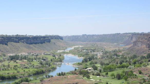
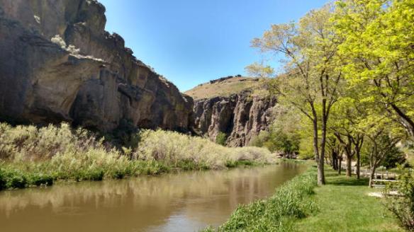
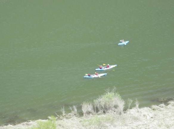
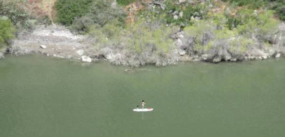
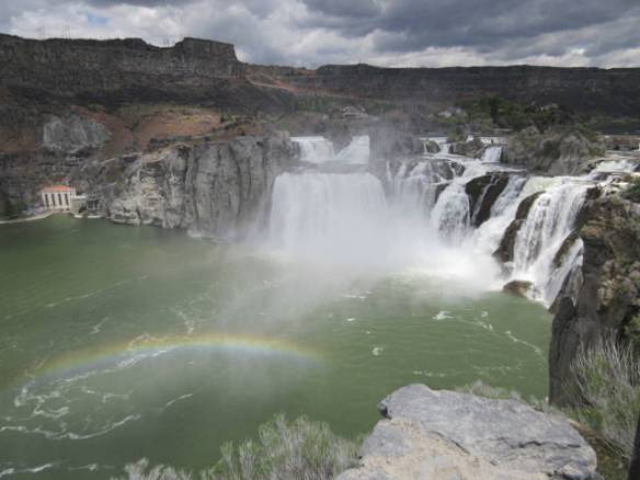
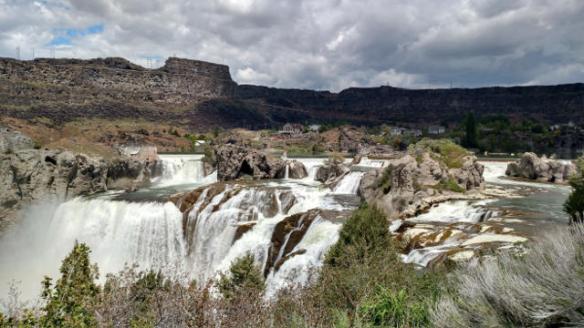
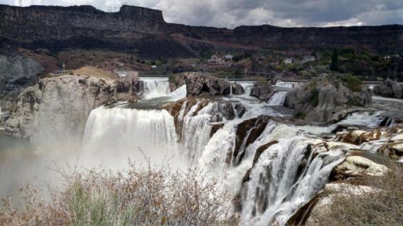
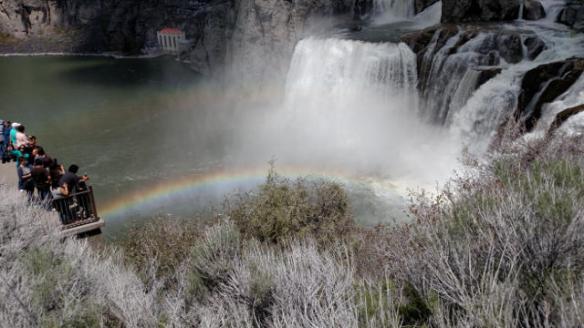
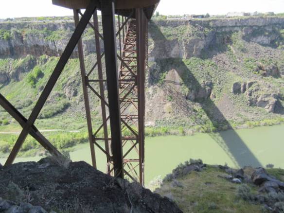
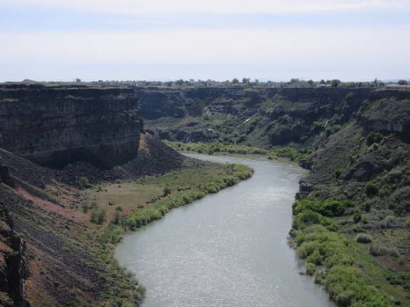
View to the west down stream on the Snake River from the Perrine Bridge. The whit specs in the river are rocks that were not visible last week.

Shopping for two weeks is not something I have a lot of experience with. During my working years I usually stopped for groceries on my way home every couple of nights. Since I’ve been living in my RV home I’ve made an effort to only shop for groceries once a week. Stores are not as nearby or convenient as they were when I lived in a house on a foundation. The idea of buying food for two weeks drove me into planning mode. I actually made a grocery list with some pre-planning of what I would cook and what leftovers I might have over the next couple of weeks. This is unprecedented for me.

There is a fairly new Walmart Super center in Twin Falls that got my shopping business. I have replenished my can goods and stocked up on breakfast cereal. The refrigerator has beef, pork and chicken that needs to be divided and frozen. I have a gallon of Orange Juice, 2 quarts of milk and a dozen eggs. I also bought the makings for two pizzas and two weeks of sandwiches. When you add in the TV dinners already in the freezer and other prepackaged stuff in the cabinets I should be fine for the duration. A meal or two in a restaurant isn’t outside the realm of possibility either.

This was the biggest grocery bill I can remember having, but I think the prices in this area are pretty good. Many of the items that I buy at Walmart regularly are a few cents cheaper here. I suspect that some of the other things I bought were more expensive but they didn’t standout. The other observation was that they charge a six percent tax on everything.

The stores in different areas put the focus on different things. For example, this Walmart seem to have a smaller selection of packaged cookies than I’m used to. Another surprise was the brand of bread I’ve come to expect. From the eastern seaboard across the south and in Nevada, I’ve been buying Natures Own bread. I came to believe it was a national brand that Walmart had a contract with. It wasn’t on the shelves at this Walmart. A brand from Oregon dominated the selections.

tud2

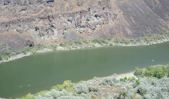
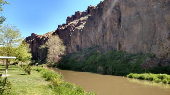
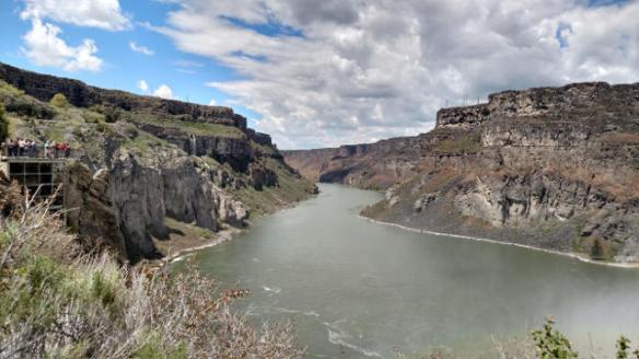
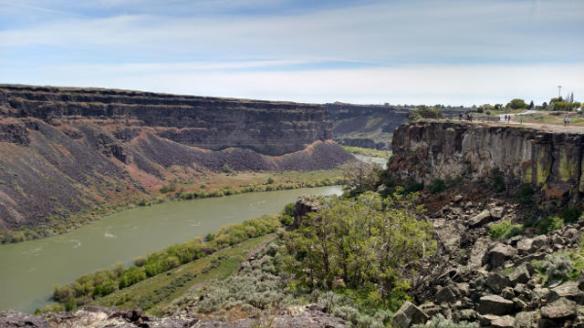
Snake River below the Perrine Bridge. The white area on the banks were not visible last week.

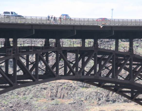
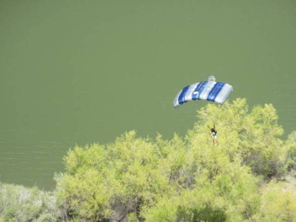
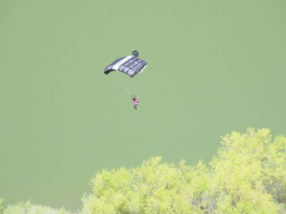
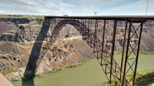
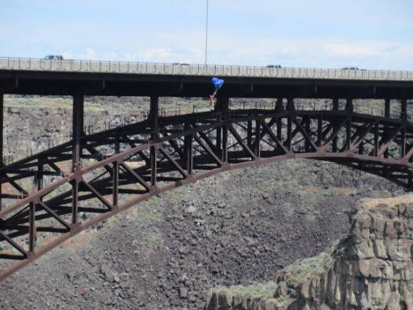
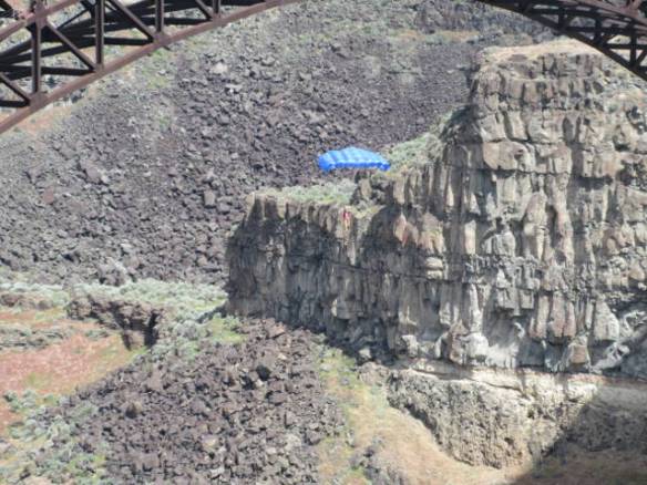
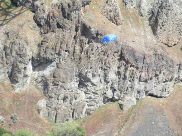
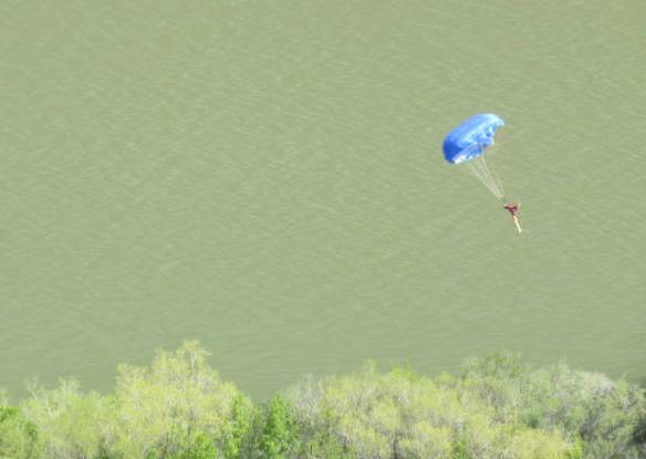
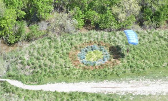
When I was out for groceries I stopped at the Perrine bridge to watch the BASE jumpers one more time. I saw one jumper and one drone helicopter operator at the bridge. What stood out is how much lower the water level was today. There is three or four feet of white rock showing on the sides of the river near the bridge. Down stream rocks are visible in the middle of the flow that weren’t showing last week. When they said they were limiting the flow to supply the irrigation canals they weren’t kidding.

Balanced Rock

Monday May 22nd 2017

I made it out to Balanced Rock today. Armed with Google directions I set out to find the elusive natural attraction. Saturday I went west from Twin Falls on US 30 looking for a road to the south leading to Balanced Rock park. I never found a road sign to provide some direction. Google’s primary directions take me south of Twin Falls on US 93 then west on a local road. These directions proved successful.

mnd6

Balanced Rock

There was a small regular road sign on highway 93 that directed me onto the west bound road. In indicated that Balanced Rock was twenty miles down the relatively narrow farm road. The road was straight for almost the entire distance. The road went up and down over rises so you could never see very far ahead, but it didn’t turn left or right. The sides of the road were lined with fields in various stages of planting. Some were hard packed dry dirt, some had been turned over in preparation for planting, still others were lush green with growing crops. I’ve decided that some of the fields may be a crop in the onion family, but for the most part I’m just guessing. Every time trees appear ahead a farm house and barn complex comes into view. The question I have to ask is which came first, the trees or the buildings. It could be either. Trees are usually located with water, but so are people.

mnd1

Salmon Falls Creek in the Balanced Rock Park

mnd2

Salmon Falls Creek looking down stream in Balanced Rock Park

I kept track of the mileage. Around 19 miles into my westward trek, the speed limit dropped from 60 to 35 and the road turned to the right. Suddenly the road twisted, turned and dropped into a big whole in the ground. The road bottomed out in the Salmon Falls Creek Canyon. Balanced Rock Park was on the left after crossing a bridge over the creek. It is a nice county park between the creek and the rock wall of the canyon.

mnd3

High canyon walls in the Balanced Rock Park.

mnd4

Spires without balanced rocks along the top of the canyon walls at Balanced Rock Park

The park has picnic tables and bathroom facilities. The water in the creek is running high, but green grass and shade trees are prevalent in the park. I parked the car and got out to look for the Balanced Rock. I studied the tops of the rock walls on both sides of the canyon. There were several spires that could support a balanced rock, but nothing that looked like the pictures I’d seen.

It is nice park that provides shade and natures symphony. In addition to the sound of the creek, which looked more like a small river today, birds, nesting in the rock ledges, were keeping a steady stream of calls and wing flutters as they moved around. Unfortunately, I still hadn’t found the Balanced Rock.

mnd5

Balanced Rock nestled in with other bolder formations on top of ridge alongside the road on the west side of the canyon.

As I was leaving the park I read the park entrance sign more closely. A faded arrow indicated that the Balanced Rock was a mile further out the road I came in on. I drove out of the canyon on the west side of the creek and near the top was a pull out to view the Balanced Rock. Other than a picnic table under a roof there was nothing notable about the pull out, but up on the top of a rock wall on the south side of the road was THE Balanced Rock. It is interesting, but the park in the canyon below was more impressive (IMHO).

mnd7

Looking back east across the top of the canyon formed by the Salmon Falls Creek. The flat land to the east contains all of the farmlands I passed through to get to the Balanced Rock.

After taking a few pictures of the rock and the surrounding area I continued on the road to the west. It started turning south and eventually intersected US 30. There were no signs on route 30 to direct one to the rock. I’d been by the intersection on Saturday, but there is no way I would have turned off US 30 at that location even if I had a GPS telling me that was the way. The road just looked too sketchy. The road in from US 90, though long, was enjoyable and much better than the road from US 30.

Relaxation at Home

Sunday May 21st 2017

It rained most of the night. A steady rain started around 10PM and was still making noise on the roof when I woke briefly at 4AM, but had stopped by 6:30. The day was mostly sunny with a high temperature in the upper 60s.

snd1

These critters live across the highway. This morning they were talking up a storm.

Today was a day to chill. This morning over breakfast I watched all of the weekend campers and travelers leave the campground. By noon the sites across from me were all empty. One of my two immediate neighbors had also departed. Around 1PM the sites started to fill up with new travelers. This evening most of the sites around me are full, but the back of the campground is empty.

While watching TV today I spent time considering my travel plans. I know in general terms my plans into the fall. I don’t know what I’m doing after October until I get back to Florida in March. In the end of October I expect to be north of Phoenix in the Verde Valley. I have been assuming I’d stay in Arizona through January, but today I started thinking about Texas.

I am now investigating the Big Bend National Park area in November, San Antonio in December and the Gulf Coast over to Houston in January. Temperatures will clearly be cooler than Arizona or Florida, but if it is a normal winter very possible. I don’t have to commit to any specific direction for another couple of months. In the mean time I’ll keep researching. The San Antonio River walk at Christmas time sounds like a must see.

Overall I think staying home and thinking was a good way to spend the day. If anything it has opened my thoughts to new travel possibilities.

Looking for Balanced Rock

Saturday May 20th 2017

I went in search of another south central Idaho natural attraction today. My goal was to visit the Balanced Rock park. I knew it was to the southwest of my location so I set off in that direction. It’s no fun when you know where your going. I assumed I’d see road signs once I got in the right area. I never saw any direction signs. Instead, I had a pleasant drive through farm land and farm towns. I have google directions now, so I’ll go to the park another day.

I drove through the same area that the emigrants to Oregon passed through in the mid 1800s on the Oregon trail. The first route west for wagon trains was along the south shore of the Snake River. They didn’t have the means to get the wagons across the river. The rolling landscape of the Snake River Plateau provided a better path than the mountains to the south and north. However, I did see one historical marker that indicated a route along the slopes of the northern mountains was used during conflicts with the natives on the main route and the route to California used during the gold rush years branched off to the south over the mountains in the Twin Falls area.

sd8

This is what the land must have looked like in the time of the Oregon Emigrants. A combination of grass and sage brush without the fence.

On the way back from my excursion I stopped at the Perrine Bridge to watch the BASE jumpers. The activity in the area was much greater than during the week. Down in the river I could see kayakers, paddle boarders, fisherman and general boat cursing. At the top of the canyon near the bridge several jumpers were in various stages of preparation for jumps. I sat on one of the benches and watched the activity for about an hour. During that time I saw three BASE jumps.

sd1

Kayaks in the Snake River 450 feet below the top of the canyon rim.

sd2

Paddle boarder in the Snake River.

sd3

BASE Jumper leaving the bridge rail.

sd4

Chute fully open.

sd5

Gliding over the river.

sd6

Barely clearing the trees.

One of the jumpers was a young woman. She was getting a lot of coaching from one of the other jumpers. She stood on the bridge, outside the rail, for a good minute or two before jumping. When she landed safely near the target she was jumping around in glee. Some of the other jumpers came over for a High-Five. I imagine it was her first jump. The guy who was coaching her jumped next. He landed in the bushes to the jeers of the other jumpers.

sd7

Young woman on her first (?) jump.

Back at the campground I have new neighbors on one side. The RV park is mostly full tonight. It has a combination of weekenders and travelers. The weekenders are the ones partying and the travelers are sleeping.

Shoshone Falls

Friday May 19th 2017

Today I set out to visit the Shoshone Falls on the Snake River. I knew it was about two miles up river from the Perrine bridge, but I needed road signs to narrow down the search. Since I didn’t see any signs on US 93 after it crossed the bridge, I took the first road east on the south side of the river. That road had a couple of small signs announcing the distance to the falls.

frd1

Shoshone Falls complete with rainbow.

frd3

Looking west, down river, from the Shoshone Falls area.

The falls viewing area is located in a city park about two thirds of the way down the canyon wall. The road hugs the cliff down to a parking area and the nice green lawns of the park. There was a big tour bus in the parking area. I’m glad I didn’t meet it on the way down the cliff. It would have used both lanes on some of the tight curves on the road.

frd2

Falls still have a high flow rate.

frd4

frd5

Another rainbow.

The Shoshone Falls are known as the Niagara of the west. They are 212 feet high about 45 feet higher than Niagara Falls and nearly 1000 feet wide. It doesn’t look higher than Niagara Falls, but the viewing area is many feet above the falls so the angel diminishes the impact of the height. The volume of water going over the falls this year is at a twenty year high. The large amount of run off has allowed the river flow managers to keep the high flow rate. On Wednesday of this week they started cutting back on the flow to allow water for irrigation in the valley. Dams up river are holding back and diverting water into irrigation canals. Ultimately the water flow will be down to just enough to support the hydroelectric plant.

There was plenty of water going over the falls today. The roar of the water could be heard from the viewing areas and plenty of mist was rising from the river. When the sun was out several rainbows were visible. Everybody had a camera from little kids to senior citizens. By far the most common was cell phone cameras, but one gentleman had an SLR on a tripod aimed at falls. I suspect he was taking timed exposures of the water flow.

When I left the falls I turned east to see if the park was more accessible and marked from the other direction. It didn’t seem to be. I ended up heading east away from my RV home on Interstate 84. I probably went fifty miles through farm lands before I decided to reverse course and return to home. I don’t think the crops are all potatoes, but I did finally identify one field that I am pretty sure was planted with potatoes. These were far enough into the growing season that they looked vaguely familiar.

Springs Back

Thursday May 18th 2017

The crappy weather of the last couple of days is over. Today was in the low 60 with mostly sunshine here in the valley near Twin Falls. To the north near the mountains it was cooler and cloudier, but still a big improvement from yesterday.

rd1

The sky over the valley was clear. The clouds hung in over the mountains.

rd2

Clouds above the snow cap mountains.

Since the weather is projected to improve daily for the rest of my stay in this area, it wasn’t necessary to force the outside activities in the cooler weather. I chose to drive around the area some more today. The direction I chose was north toward the mountains. They’re further away than I thought. I ended up in Arco ID about 120 miles from my current RV park. Arco also happens to be where I’ve booked my next stay. What started as “Let’s check the route north” turned into a full blown dry run of the next week’s travel.

rd3

rd4

This area of the country had a particularly wet winter. When I was in Reno NV last week they were talking about the high amount of snow pack in the Sierra Mountains and the rivers were running at the highest levels since the mid 1990s. Here in southern Idaho a similar story is being told. The amount of snow in the mountains is very high and rivers are running at all time high flow levels. There has been some minor flooding and more is feared. The temperature is forecast to reach the mid 80s next week.

rd5

The high peaks in the mountain ranges are all still snow covered. It is very pretty to see the green lower slops transition into white snow tops. It is possible that some of the highest peaks will remain snow covered this summer. That is not the norm for this area.

This evening is the first day since I arrived here that ended in full sunshine. The lack of clouds have allowed the full impact of the late sunset to be visible. As of 9:15PM there is still enough daylight to walk around outside with out the need for a flashlight. The official sunset for this area was just before 9PM.

What happened to Spring

Wednesday May 17th 2017

Today’s weather was more appropriate for March than May. The rain stopped with the passing of the cold front overnight. In its place we have cold temperatures and strong winds. It barely cleared 40 degrees today and the wind was blown continuously. An occasional shower resulted in wind blown dampness. It was miserable outside.

To break up the day, I went for a drive with a stop for a few food items. This areas has rolling terrain. It isn’t hilly, but it isn’t flat either. It is primarily grass lands with scattered groups of trees used for ranch land and farming. As usual I have no idea what kind of crops were being grown. Fields were in different states of cultivation from fully covered in green growth to bare dirt. The one thing they all had in common was massive irrigation systems.

The most common irrigation system was the pivot style that creates circular cultivated fields when viewed from thirty thousand feet in an airplane. There were also long lateral sprinkler arrays that traveled down the length of the fields under there own power. A variation on those seemed to be designed to be rolled across the field possibly by human power. I imagine irrigation systems are very important during the growing season, but why were many of them running today after about 12 hours of rain.

wes1

A reminder of what spring is supposed to look like.

The campground is much closer to full tonight than it has been. One reason is that most of yesterday’s arrivals didn’t leave in this mornings winds. I think only about two rigs left this morning. New campers having been arriving all afternoon. The weather is forecast to be better tomorrow. It may even make it to 60 degrees. I suspect there will be many early departures in the morning.

Weather Watching

Tuesday May 16th 2017

The day started cloudy and cool. It got progressively worse as the day went by. Tonight it is a full rain storm with heavier weather approaching. The overnight low for this area is forecast to be a degree or two above freezing.

tue1

View of the Snake River Canyon depth from under the Perrine bridge.

It takes a little more attention to understand the TV weather forecasts in this area. All of the TV stations have very large viewing areas. Each station seems to have many rebroadcast transmitters. I think the stations I’m watching are actually located in Boise over 100 miles from here. The weather forecasts cover north central Nevada, south central Idaho, southwestern Idaho, western Idaho, central Idaho, southeastern Oregon and a few other areas. They talk through the forecast for each area by local names that aren’t necessarily on the map. This area is called the Magic Valley for some reason.

tue2

Looking to the east from the Perrine bridge. The bump on the rim near the left of the picture is the Evel Kneivel jump ramp on the south rim.

The gloomy conditions this morning set the tone for my day. I didn’t leave the campground all day. I watch the pool repair crew sandblast the empty pool. They’re preparing it for a new coat of gunite, before they fill it. The pool is scheduled to open by Memorial day weekend. The sandblasting provided an interesting background noise. It was so constant that I didn’t hear the lawn mowers until they arrived at my site. Watching the guy scoot around on the mower was another few minutes diversion.

The pictures in this blog entry are from yesterday. I’m not happy with the color quality and sharpness of the pictures from my Canon PowerShot ELPH 360HS camera. I did some experimenting with cleaning them up with software, but I don’t see a big improvement. The color quality and brightness from my cell phone are much better. The camera’s advantage is that it has an optical zoom of 12X. If I don’t find a way to post process the pictures, I may need to buy a new camera.

Snake River Canyon

Monday May 15th 2017

Today was a cool sunny day. The high temperature was just over 60 degrees, about 10 degrees lower than the seasonal expectation. After three straight travel days, I was not ready for a lot of tourist activity today, but cooler temperatures and rain are forecast for the next three days. I needed to take advantage of the sunny day.

mon2

I. B. Perrine Bridge over the Snake River in Twin Falls Idaho

Late in the morning I drove back to the I. B. Perrine bridge across the Snake River. I crossed it coming north yesterday. From the road approaching the bridge it is very unremarkable. The ground is level on both sides of the canyon holding the river so on approach the need for a bridge is hidden. It is only once you are on the bridge that the canyon is revealed. The river is not visible from a vechile crossing the bridge. It is too far below.

mon3

View to the East from the Perrine Bridge area. The Evel Knievel launch ramp is in the south bank in the middle of this picture.

There are parking lots on both sides of the bridge to view the canyon and a visitors center on the southwest side. The bridge is a truss arch span 1500 feet long and 486 feet above the river. I walked under it on each side of the canyon and I walked out to the center of the bridge. It shakes and vibrates as each truck passes across. It wasn’t the most comfortable experience out on the shaky bridge 486 feet above the water, but the view was well worth it. To the west the canyon floor has a golf course on both sides of the river. To the east waterfalls and the dirt launching ramp for Evel Knievel’s unsuccessful attempt to jump across the Snake River Canyon on a steam powered Skycycle rocket can be seen in the distance.

mon4

Waterfall on the south rim of the canyon.

mon5

Statue “The Twins” on the rim southeast of the bridge.

The other thing the bridge is know for is BASE jumping. It is one of the only places in the United States that it is legal to parachute jump from the structure. While I was there several jumpers took the leap. How they can do it is beyond my understanding. I found it very difficult to watch as they stood on the bridge railing before jumping.

bj1

BASE Jumper preparing to jump

bj2

Over the edge with the parachute starting to deploy

bj3

Parachute open and sailing toward the river below. 

bj4

bj5

Is he going to land in the water?

bj6

Landing near a target painted on the floor of the canyon beside the river.

Another major storm front is moving in off the Pacific Ocean. It will bring rain to this area tomorrow through Thursday. Some areas at altitude North, South, East and West of here have winter storm warnings in effect. The Elko NV area that I was in over the weekend may get as much as two feet of snow. I’m glad I’m not still in that area. The Sun Valley area to the north of here is expecting about 10 inches of snow. I don’t think I will be traveling too far away from this area of the Magic Valley over the next couple of days.

Travel Day to Twin Falls Idaho

Sunday May 14th 2017

The noisy departure of one of my neighbors got me started early this morning. I was up and preparing breakfast by 7:30. It was way earlier than I needed to be up. I only had 120 miles to my next destination.

I tried to prepare for travel slowly, but I was on the road north from Wells NV at 9:30. I had a straight run north on US 93. The road had a single lane in each direction except for the big climb out of the valley which added another climbing lane. I needed it, running at the 70mph speed limit was two fast for me.

The first section of road was through an area labeled as a “Deer Migration Crossing”. There were elaborate structures and high fences to keep motorists and deer apart. I say two bridges for the deer to cross and several tunnels under the road just for the animals to cross. I didn’t see any deer. I did see reference to hunting, so I wonder if the area is designated recreation land.

As I went north the ground cover changed. It started as gravel with low bushes and transitioned to grass with low bushes. Shortly after crossing into Idaho, the bushes disappeared and good cattle grazing land appear. It changed to cultivated farm land as I got nearer to Twin Falls. Somewhere along the way I also lost over two thousand feet in altitude even though I thought I was climbing.

sun1

Site 24 at the Twin Falls/Jerome KOA.

I am at the KOA just north west of Twin Falls Idaho in the town of Jerome. I plan to be here for ten days to checkout the southern Idaho attractions. The campground is in a good location, but the sites are a little close to each other. My site is about fifty feet from US 93, so it won’t be quiet. The trees in this area are in full foliage. The one beside my RV blocks my satellite dish so I’m using the campgrounds cable TV hookup. I’ll have to live without a couple of stations I have started to frequent. It isn’t worth moving to get a chance at a better satellite shot.

I also moved back into the Mountain time zone. The sun is setting later by the clock in this area. It is now 8:30 MST and dusk is arriving.