Horseshoe Bend in the Colorado River

Sunday September 10th 2017

It was a beautiful late summer day at Lake Powell. The sun was bright and the temperature peaked in the high 80s. I started watching the TV coverage of Hurricane Irma during breakfast. It really fowled up my day, but nothing like the people actually experiencing the storm. DirecTV has a special channel with rotating coverage from various TV stations in Florida. That coverage along with the Weather Channel made me feel like I was in the middle of the storm. I finaly pulled away from the coverage around noon to get the day started.

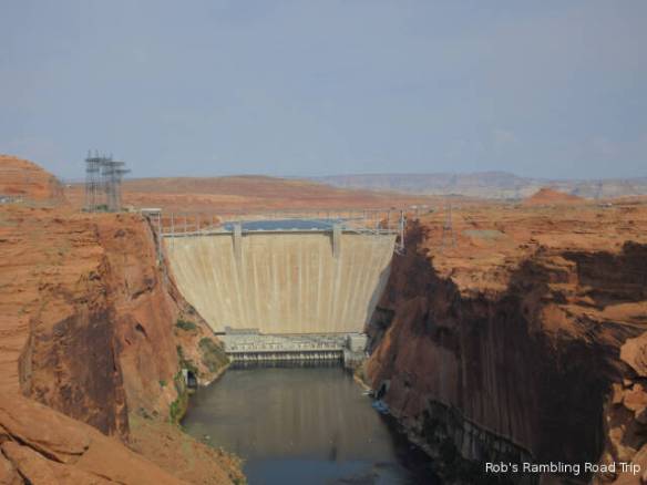
My original plan for the day was to drive one hundred and thirty miles to the North Rim of the Grand Canyon. Watching the hurricane coverage made traveling for five hours round trip for a limited time visit a non-starter. Instead I did a few things around Page, AZ. My first stop was at the Glen Canyon Dam visitors center. I watched a very interesting film on the building of the dam and walked across the bridge overlooking the dam. They offer a tour of the dam, but I wasn’t interested. I’ve taken the tour of the Hoover dam and don’t think this one would be much different.

r3t2017-09-10_19-4511

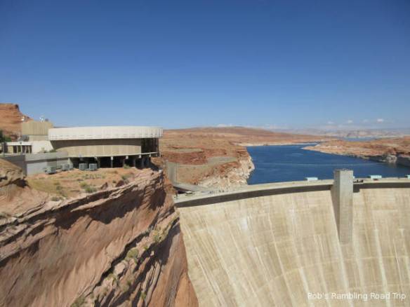
Glen Canyon Dam and the Carl Hayden Visitors Center

r3t2017-09-10_19-4510

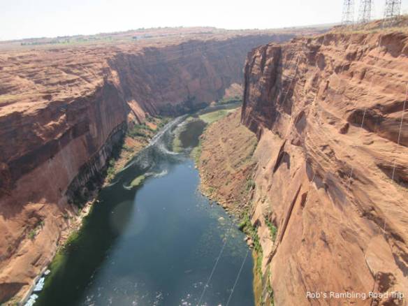
Down river view from the bridge crossing the river at the dam.

r3t2017-09-10_19-458

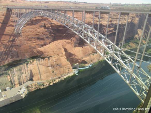
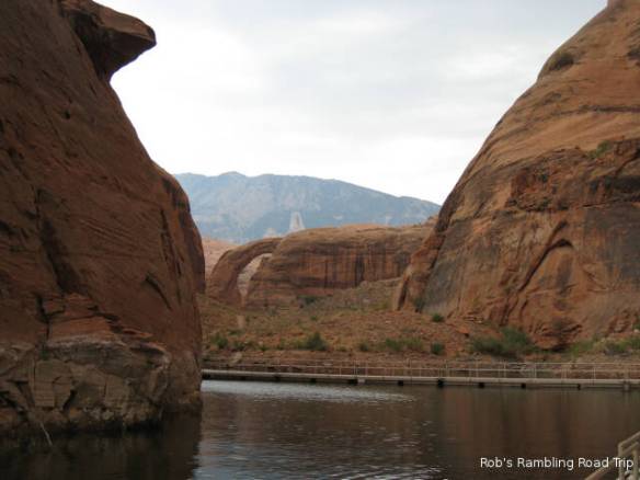
The bridge across the river and a view of the raft trip boarding area.

r3t2017-09-10_19-457

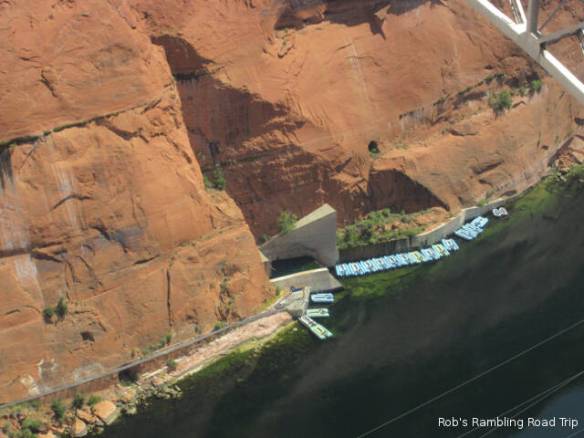
Closer view of the raft loading area.

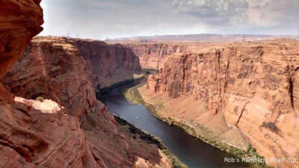
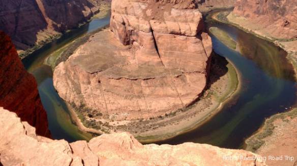
From the dam visitors center I drove southwest to the Horseshoe Bend trail head. A hike of a little over a half mile brings you to the rim of the canyon overlooking a horseshoe bend in the Colorado River. It was a very popular place today. A continuous flow of people were hiking out and back. The view is spectacular. The river appears green (probably from slime) about 1,000 feet or so below. Tomorrow I’m taking a raft trip along the Colorado river. I’ll have to check the water color through this area.

r3t2017-09-10_19-456

Sunday walk in the Park on the trail to the Horseshoe Bend overlook.

r3t2017-09-10_19-455

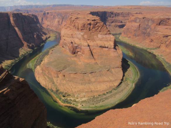
Horseshoe Bend in the Colorado River a thousand feet below.

r3t2017-09-10_19-452

r3t2017-09-10_19-451

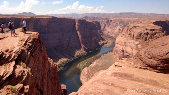
Brave or stupid? I can’t get close to the edge when there are people behind me. If I feel safe I can get within a foot or two of the edge.

On my way back from Horseshoe Bend I stopped at Walmart for groceries and other supplies. I was getting down on healthy food and junk food. My last couple of meals were from packages and cans. They were perfectly eatable, but have more sodium than I probably need. I now have fruit, meat and eggs on the healthy list and cookies, bread and cupcakes on the junk food side.

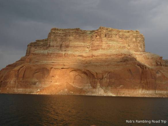
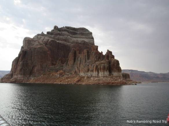
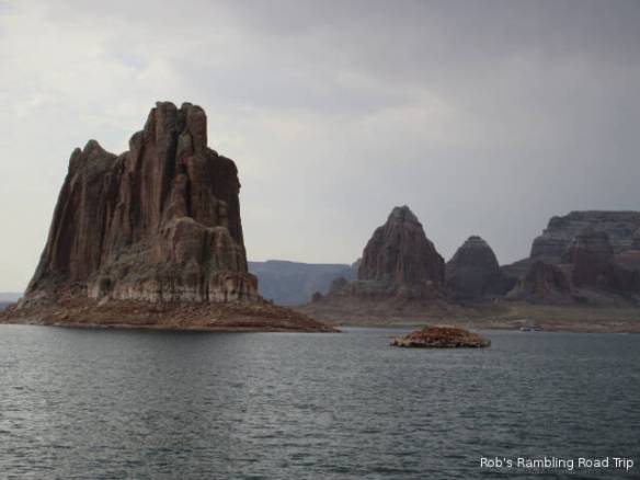
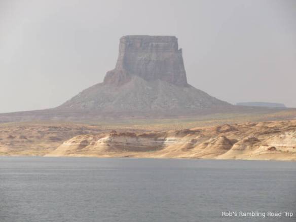
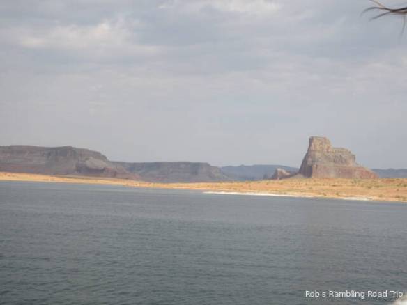
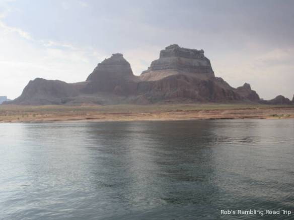
Back at camp for the late afternoon/early evening walk I saw a number of jack rabbits. On previous walks the smaller bunnies were more prevalent. These bigger rabbits are more skittish than the little bunnies. The setting sun also highlighted some nice colors on the mountains growing out of the lake.

r3t2017-09-10_19-454

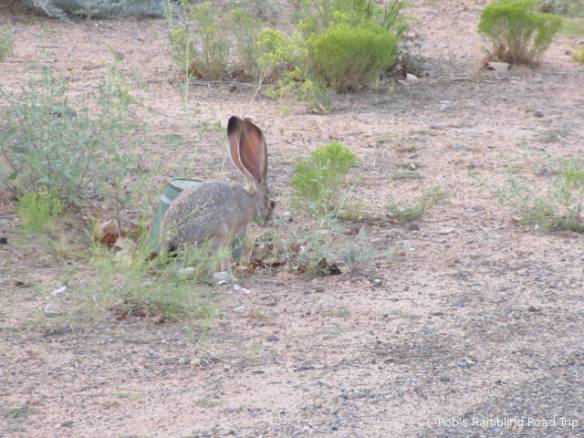
Jack Rabbit about 20 feet from me.

r3t2017-09-10_19-453

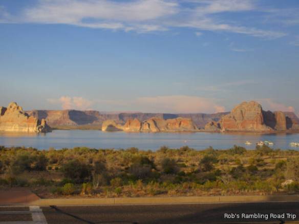
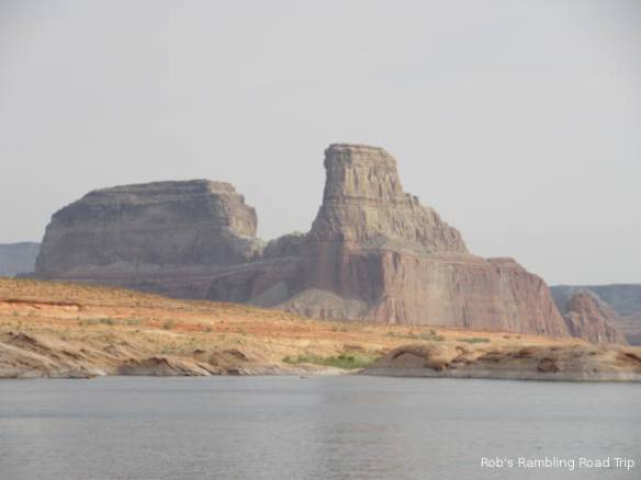
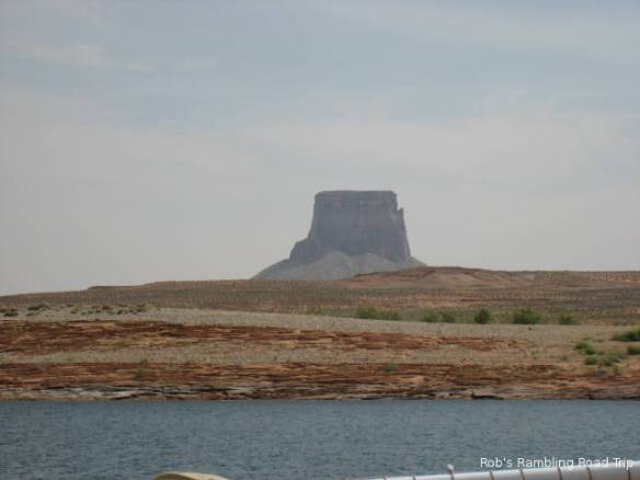
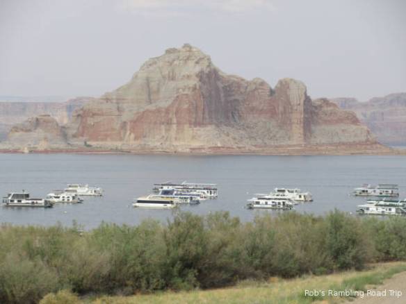
Lake Powell in the setting sun.

Tomorrow I have to be in the town of Page to check in for my raft ride down the river. From the downtown office you take a bus to the base of the Glen Canyon dam through a 2 mile long downhill tunnel. That sounds like an interesting start to a boat ride. I should mention that this is not supposed to be a white water raft ride. You get bussed back to Page from the landing at Lee Ferry.

Lake Powell

Saturday September 9th 2017

This was the first truly rainy day I’ve had since June. It started raining light but steady last night around midnight and continued through early afternoon today. When I got up this morning it was very foggy, but by late afternoon the sun came out and brightened things up.

Sightseeing was not in the cards for today. I spent much of the day watching the Weather Channels coverage of hurricane Irma. The combination of Information, Instruction, Warning and Reassurance is strangely compelling. Hopefully, people will be smart and safe. Property can be replaced.

I’m including more pictures of yesterday’s boat excursion on Lake Powell in this blog entry. I really enjoyed the trip to Rainbow Bridge. It is interesting to think what it would have been like before 1963 when the dam filled Glen Canyon to create Lake Powell. The fact that this massive body of water has been around for less time than I’ve been alive is hard to contemplate.

r3t2017-09-09_18-291

r3t2017-09-09_18-292

r3t2017-09-09_18-293

r3t2017-09-09_18-294

r3t2017-09-09_18-295

r3t2017-09-09_18-296

r3t2017-09-09_18-297

r3t2017-09-09_18-298

r3t2017-09-09_18-299

r3t2017-09-09_18-2910

r3t2017-09-09_18-2911

r3t2017-09-09_18-2912

r3t2017-09-09_18-2913

r3t2017-09-09_18-2914

r3t2017-09-09_18-2915

r3t2017-09-09_18-2916

r3t2017-09-09_18-2917

Late in the day today I took advantage of the returned sunshine to walk to one of the boat launch areas. There were many people putting water craft of every type in the water. I saw everything from canoes and kayaks to high speed boats. The National Recreation area is definitely a draw for people wanting to play on the water.


Rainbow Bridge National Monument

Friday September 8th 2017

It’s been a long but exciting day. I got up early to check in for my boat to the Rainbow Bridge National Monument at 7am this morning. The boat left the Lake Powell Wahweap marina at 8am and returned at 4PM after 100 plus miles on the boat.

The weather was labeled as partly cloudy. As long as you recognize that partly cloudy also means occasional light showers, the forecast was accurate. The lack of a baking sun was a good thing. I road on the open upper deck most of the trip. I retreated to the lower covered area during one heavy wind and light shower on the way home. The top deck was ideal for taking pictures although I got a little carried away. I took over 900 pictures.

RainbowBridge01

Rainbow Bridge

RainbowBridge02

Path leading up the canyon to the Rainbow Bridge. Note the high water mark on the rock walls. In 1983 when the Lake reached its peak level for the first time the water was around 20 feet higher.

slot1

Narrow canyons on the way into the Rainbow Bridge National Monument

slot3

Another look behind the boat at the narrow canyon the boat passed through.

The battery in my primary point and shoot camera started displaying a warning when we were only three quarters to the Rainbow Bridge. I switched to my backup point and shoot that I brought along just in case. At the Rainbow Bridge National Monument I switched to my cell phone camera because it produces more brilliant color in the pictures. The cell phone started complaining about low battery a third of the way back. It was also difficult to hold onto in the wind on the moving boat. I finished the trip using my backup point and shoot camera. As I’ve been writing in my blog entries for the last month, I’ll post all of the pictures in a Google Photos album once I get a good internet connection. This blog contains a handful of nice pictures. When you take 900 plus pictures many of them are not the greatest. Taking pictures into the sun’s glare or completely in the shadows will cause “bad” pictures.

The Rainbow Bridge is an arch created by flowing water. It is located at the higher end of a series of narrow canyons in the shadow of 10,388 foot Navajo Mountain. It is only accessible by boat or very long hike from near Navajo Mountain. The boats tie up to floating docks that are adjusted periodically to account for the changing lake height. The first part of the half mile trail is along the floating docks followed by a trek along the base of the canyon wall.

r3t2017-09-08_20-111

This series of pictures are from the trip to the Rainbow Bridge.

r3t2017-09-08_20-112

House boat with extra water craft in tow.

r3t2017-09-08_20-113

r3t2017-09-08_20-114

r3t2017-09-08_20-115

r3t2017-09-08_20-116

Table butte.

r3t2017-09-08_20-117

r3t2017-09-08_20-118

r3t2017-09-08_20-119

r3t2017-09-08_20-1110

r3t2017-09-08_20-1111

Bad weather behind the boat. It never really caught up with us.

r3t2017-09-08_20-1112

r3t2017-09-08_20-1113

r3t2017-09-08_20-1114

r3t2017-09-08_20-1115

r3t2017-09-08_20-1116

Fancy house boat with the water craft docked to the back.

It rained during the hike from the boat to the Rainbow Bridge. The rain was just hard and long enough to get you wet. It also made my pictures at the bridge a little duller. The sun was out in full force by the time I got back to the boat.

The trip back included a stop at the Dangling Rope Marina to give the store and ice cream stand run by the same concessionaire as the boat ride a little business. There was no narration on the return trip. It was generally a high speed run except when the captain had to reduce his wake to pass one of the many houseboats. Apparently, people don’t like their home rocking in the waves.


A Potpourri Kind of Day

Thursday September 7th 2017

I was up early even by Utah time. Using local Arizona time it was absolutely ridiculous. Let’s just call it practice for tomorrow morning. I need to be at the Lake Powell Lodge at 7am to check in for my boat trip to Rainbow Bridge National Monument. It’s about a 50 mile boat trip each way.

r3t2017-09-07_20-091

Glen Canyon Dam

r3t2017-09-07_20-094

Colorado River looking down stream from the Glen Canyon Dam overlook.

Today was a potpourri kind of day. I started the day with a visit to the Glen Canyon Dam overlook. For some reason I thought it looked like a concrete cork in a rock bottle. There is no physical similarity just an odd metaphor that passed through my brain. Maybe from lack of sleep.

Back at camp I did the laundry. This was one of the cheaper campground laundries. A load of wash was a dollar and a drier run was only fifty cents for a 35 minute run. I probably should have coughed up another fifty cents, because some of the clothes weren’t completely dry. A couple of things are still hanging around in the RV tonight. I just didn’t want to hang around the laundry for another half an hour.

r3t2017-09-07_20-092

More house boats in Lake Powell.

It clouded over late in the afternoon. I took advantage of the filtered sunlight to take another walk around the area. I seemed to startle many little cotton tailed rabbits. One bigger rabbit that looked like it might have been a jack rabbit saw me long before I saw him. We had a staring contest before he hopped into the brush.

The cloud cover that made the walk comfortable was threatening to make the walk dangerous. A thunderstorm was moving in. Lightning was visible on the horizon, so I had to cut my walk short and return home. I was back only a few minutes before the sky opened up. It rained hard for a half an hour. It has rained a few more times for shorter durations since then. Hopefully the rain will wash some of the dust off my motorhome and car.


Travel to Lake Powell

Wednesday September 6th 2017

I am at the Lake Powell Resort and Marina in the Glen Canyon National Recreation Area for the next week. I departed Hurricane Utah at the 11am checkout time and climbed up onto the Arizona Strip section of the Colorado Plateau for the 130 plus mile trip to Lake Powell. The Colorado Plateau is the high ground surrounding the Colorado River. Over the last couple of weeks I learned that Zion and Bryce canyons are both in the Colorado Plateau. The Arizona strip is the name given to the part of Arizona north of the Colorado River that is somewhat isolated from the rest of the state.

r3t2017-09-06_20-025

Site D-75 at the Lake Powell Resort and Marina campground.

After the rather steep eight percent grade climb out of Hurricane UT onto the plateau, the trip was fairly easy. The weather threatened rain all day but the temperature still got into the high 90s. At one point on the drive a brief sprinkle of rain hit the windshield accompanied by a strong cross wind. The rain was inconsequential, but the wind caused me to tighten my grip on the steering wheel. I arrived at the campground on Lake Powell after a little over two hours of travel. It was officially 12:20 local time, but it’s very hard to know what time it is.

I’m in Arizona so it is officially Mountain Standard Time or 1 hour earlier than Utah which is using Mountain Daylight time. Trying to figure out the time is hard. According to the map, Utah is only a few hundred yards from where I’m parked. My cell phone seems to prefer a cell tower in Utah so it reports time in MDT units. If I walk toward Lake Powell, my phone picks up a cell tower in Arizona and reports time in MST units. To further complicate things, I have no local TV stations to orient my sense of time. My DirecTV satellite stations are all in Eastern Daylight time. I finally found a Page Arizona radio station that may or may not help. I’m not going to have a clue what time it is while I’m here.

r3t2017-09-06_20-021

Some of the larger boats at the Resort’s dock with house boats out in the lake.

r3t2017-09-06_20-024

Buttes in the lake. I don’t know which of the lines on the rock represent the high water line.

r3t2017-09-06_20-022

Wide view of this section of Lake Powell. The Glenn Canyon dam on the Colorado River is a mile or more to the right.

r3t2017-09-06_20-023

This Roadrunner (?) was very entertaining.

I have a good view of Lake Powell from my campsite. The lake’s water level is low, but I’m not sure how low. Unlike Lake Mead behind the Hoover Dam, Lake Powell doesn’t seem to have as pronounced a high water mark on the surrounding rock walls. I hope to learn more about the water level while I’m here. On Friday, I’ve booked a boat excursion on Lake Powell. Maybe, I’ll learn more then.

Winter Planning and Travel Preparations

Tuesday September 5th 2017

The heat continues in southern Utah. Once again it topped out in the low hundreds. We may get a thunderstorm or two before morning. Right now, in the late evening, a light show of sorts is visible on the southern horizon.

I started the day with another attempt to get a reservation at the Corp of Engineers park near Fort Meyers. It is frustrating, because there are only a few sites available at the beginning of the reservation window 6 months out. Again this morning someone else clicked their mouse a little quicker than I did. Later in the morning I started looking into plan B. My overall goal was to be on or near the gulf coast of Florida during the month of March to attend a few Baseball Spring Training games. The months of February and March are the high season for Florida snowbirds. I’ve had the two weeks from March 10th to March 24th booked since April. I just needed to fill in before and after that reservation. After the 24th of March turned out to be fairly easy. Probably because Easter is early on April 1st, there is a lot of availability at the end of March. Many snowbirds try to be home in the north by Easter.

The gulf coast of Florida from just north of St Petersburg south to Naples is premium territory. It not only is in high demand it is also high priced. I could find two and three night stays at the state parks, but the weekends were booked solid. The one private campground I talked with won’t take reservations for under a month until November. I decided to look further inland where fewer people want to stay. I found ten days of availability at the Corp of Engineers campground beside the Ortona lock on the Caloosahatchee Canal that crosses the state from Fort Meyers to Port St. Lucie. So I’m set for the month of March in Florida. Now I just have to figure out November through January. February will be a cross country travel month.

r3t2017-09-05_21-231

A road passes through the break in the cliff shown in this picture. Tomorrow I’ll drive the motorhome through that break in the cliff as I start my travels to Lake Powell.

The planning exercise took most of the morning. This afternoon I started to pick up for tomorrows move to the Lake Powell area. I also made a run to Walmart for groceries. All of the Halloween stuff from decorations to candy is out. Pushing the seasons even more the garden area is cleared out and it looks like they are getting ready to put the Christmas stuff out. I know it’s after labor day but really.

The Calm after the Weekend

Monday September 4th 2017

The holiday weekend is over. Life at the campground has returned to the slow mid-week pace. The smell of campfires and sounds of kids playing have gone away. The weekend campers started leaving last night after dark. A couple of RVs from California packed up after the sun went down last night and departed for home during the cool overnight hours. Interstate 15 west of Las Vegas heading for the LA area is notorious for backups on holiday weekends so that may be another consideration. This morning many others from Utah, Nevada and Arizona packed up and left.

It was another above normal day in the low 100s. We are getting some relief this evening. It has clouded over and is threatening a thunderstorm. Monsoon moisture is returning to the area so the temperatures will be lower, but afternoon thunderstorms will become the norm. The probability of storms increases each day this week.

r3t2017-09-04_18-073

Northeast bound on Interstate 15 in the Virgin River Gorge of Arizona.

r3t2017-09-04_18-072

Northeast bound on Interstate 15 in the Virgin River Gorge of Arizona. Taken through the dirty windshield.

r3t2017-09-04_18-071

Northeast bound on Interstate 15 in the Virgin River Gorge of Arizona.

After spending yesterday at home, I had to get out today. I went south on Interstate 15 toward St. George with the intent of stopping at an outlet mall. When I got into the area of the mall, I lost my interest in shopping so I continued on down the road. I drove out of Utah, through Arizona and into Mesquite Nevada. The southwest bound traffic I was part of was quite heavy through the long down hill trek through the Virgin River Gorge. This is another section of creative highway engineering. The road crosses the river several times and at in one section is built right over the river bed.

In Mesquite I walked through a couple of casinos and played a few slot machines. I never made enough money to leave with a profit, but I got a good period of play for twenty bucks. Traffic on the return trip wasn’t as bad. Once again I drove by the shopping ares of St. George.

Sunday at Home

Sunday September 3rd 2017

It was another hot day in Hurricane Utah. It topped out just north of one hundred degrees Fahrenheit. It’s not bad for the first two thirds of the daylight hours, but the last few are something else. From about 4:30 to 7:30 the sun angle bakes in on the side of the RV. The inside walls are hot to the touch, the outside wall comes close to burning the skin. I close all the blinds and turn on both AC units to keep the inside in the eighties.

I got sidetracked on a computer geek task today. I’ve been trying to find an easier way to deal with pictures in my blog. The last couple of posts with Zion National Park pictures have included full size pictures rather than scaled down images. I hoped that this would save processing time when I prepare the blog. It takes a couple of minutes per image after I choose the ones I want to share. Unfortunately, the approach I tried doesn’t save any time. It also doesn’t work very well with a marginal internet connection like I have here. Today I worked on a way to automate the process of scaling the images to a blog friendly size.

r3t2017-09-03_18-441

r3t2017-09-03_18-442

r3t2017-09-03_18-443

The pictures I’ve included in tonight’s blog are from yesterday’s trip to the Kolob Canyons section of Zion National Park. They were all re-sized using a slightly more automated approach than I was using. I’ve also included a watermark on all the images. I’m going to continue to research and experiment with better ways to handle photos and possibly a new look (theme) for the blog.

I’ve also been working on planning for the November through March time frame. I got up early for the fourth morning to try for a site in the Corp of Engineers campground in the Fort Meyers FL area during the beginning of March still without success. There are other possibilities that I will start to explore for that time frame, but I’m back in search of a plan for November through February. Texas from Interstate 35 east into Louisiana is going to be a good place to avoid for a few months. Many of the campgrounds near Houston were flooded and the others are likely to be used by people displaced from their homes. I don’t want to compete with their needs for a site.

I’m now looking at Southern California, Southern Nevada and Southern Arizona for month or two stay at the start of the winter. I don’t know anything about the California options. Nevada would be the Las Vegas or Laughlin areas and Arizona would be on the boarder with California or Nevada. I don’t really want to stay in the Phoenix area. The small amount of research I’ve done so far indicates that California is expensive if you get near a population center. I need a population center for entertainment. The research continues.

Kolob Canyons of Zion NP

Saturday September 2nd 2017

Today started hazy in the low 70s. The temperature rose rapidly to a peak in the low 100s, but the haze remained all day. After a slow breakfast with some Saturday morning TV I headed up the interstate to the Kolob Canyons unit of Zion National Park.

The Kolob Canyons are on the northwest side of Zion National Park. It is not connected with any of the other areas of the park by road. There are a series of trails that connect the areas, but they are many miles long. The Kolob Canyons area is a single scenic drive along the high ground with views of the canyons. This contrasts with the Zion canyon area which is along the floor of the canyon with views of the walls towering above.

kolob 1

kolob 2

kolob 3

kolob 4

kolob 5

I drove the scenic drive stopping at many of the pull offs to take pictures and enjoy the view. At the end of the drive there is a trail out to a scenic overlook. The half mile trail is combination of easy path and scrambling over rocks climbing up and down some moderate hills. The view at the end is worth the effort. The expanse beyond the overlook is impressive.

kolob 6

kolob 7

kolob 8

kolob 9

kolob 10

It only took a couple of hours to tour the Kolob Canyons area. Unlike the main unit, the crowds were not heavy. I only took around 100 pictures. The haziness made many of them look washed out. I’m only including ten of them here.

Once I got back to camp I pretty much hibernated in the air conditioned comfort of the RV. As you’d expect the campground is busy for the holiday weekend. Unlike during the week, I have neighbors on the sites beside me. They are closer than I’d like but on holiday weekends you take what you can get.

More from Zion National Park

Friday September 1st 2017

I stayed at home today. After yesterday’s high level of activity associated with the hiking in Zion National Park and an interrupted night’s sleep, I wasn’t in the mood for much activity today. I had the alarm set for 5:45 this morning to attempt to get a reservation next March 1st in the Fort Meyers area of Florida. Knowing the alarm was going to go off early, I kept waking up to see if it was time to get up yet. I know that’s why I set the alarm, but … I didn’t get the one available site, just like I missed the available sites on the twenty fifth and twenty sixth of August. I’ll try again tomorrow morning. There are three sites available then.

The labor day weekend is here. I don’t know what happened to the summer. I’ve been in the Utah area since the end of June. My stay in West Wendover NV in early July was within yards of the Utah boarder. Next week I’ll move to the Lake Powell area. I’ll technically be in Arizona, but within yards of Utah. In West Wendover I had Salt Lake City TV channels. I’m not sure if I’ll have Salt Lake City or some Arizona based stations in the Lake Powell area. All of Utah seems to have the same Salt Lake City based stations. Unfortunately, this is important to the impression you get of an area. I’ve come to understand and know what to expect of the news broadcasts out of Salt Lake City.

I’m going to share more pictures of Zion National Park in this blog entry. The way I’m including these pictures is different from the previous method. These pictures are links to the full scale versions of the pictures. The way I’ve been including them involved extensive, time consuming, editing to reduce the size of the images before uploading them to the Word Press blog hosting site.

Zion National Park image 1

Zion National Park 2

Zion National Park 3

Zion National Park 4

Zion National Park 5

Zion National Park 6

Zion National Park 7

Zion National Park 8

Zion National Park Image 9

Zion National Park Image 10

Zion National Park Image 11

Zion National Park Image 12

Zion National Park Image 13

Zion National Park Image 14

Zion National Park Image 15

Zion National Park Image 16

Zion National Park Image 17

Zion National Park Image 18

Zion National Park Image 19

Zion National Park Image 20

Zion National Park Image 21

This weekend I plan to visit the Kolob Canyons Unit of Zion National Park. This area is north of here off of Interstate 15. It isn’t as heavily visited as the main unit. Hopefully, it won’t bee too crowded on the holiday weekend.