Checking out the area around Cottonwood AZ

Wednesday September 20th 2017

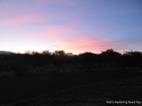
Today’s weather was a repeat of the last couple of days. It was a day with full sunshine, breezy and a high temperature around 90 degrees. When I get up in the morning it is cool in the sixties and by the time I go to bed the temperature has returned to a comfortable level. The wind is forecast to pickup tomorrow as a cold front moves through the area.

r3t2017-09-20_20-211

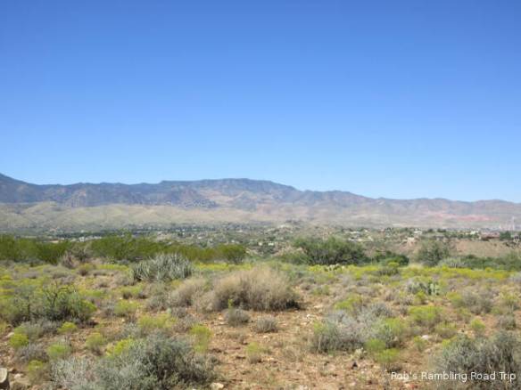
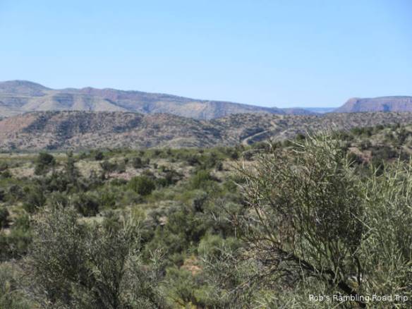
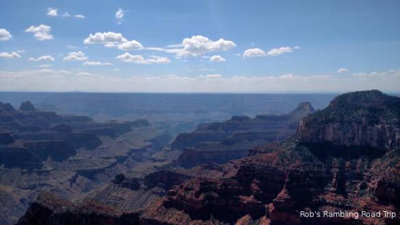
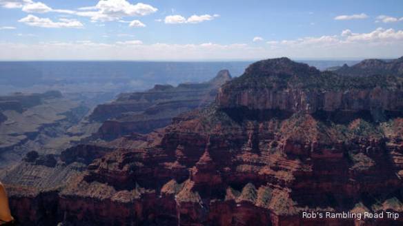
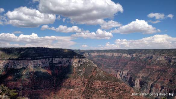
Somewhere near the top of one of those mountains is Jerome AZ.

I spent the morning reading with the TV on as background noise. I can’t really get into the locally (Arizona) produced morning programs. It seems like all of the major TV channels have a show featuring one to three local personalities talking about local and national feature stories. I can’t get interested in the new chef at the local fine cuisine restaurant pr chiropractic advice for school kids carrying back packs. There are so many of similar programs that I think they’re digging pretty close to the bottom of the barrel for interesting stories.

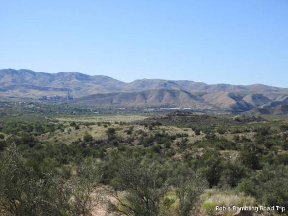
This afternoon I got around to taking my typical area familiarization drive. I drove through the historic downtown of Cottonwood out to the town of Clarkdale and then up the mountain to Jerome. The entire area owes its existence to the establishment of copper mines in Jerome around 1870. Clarkdale at the base of the mountain was the site of the smelting operation and Cottonwood was established as a non-company town in the early 1900s. The mining operation ended in the early 1950s. Providing cement for the construction of the Glen Canyon dam in the early 1960s followed by tourism has saved the area.

The downtown area of Cottonwood looks like an attempt to maintain a snapshot of what the community looked like in first half of the last century. Shops in buildings constructed in the Spanish influenced style of the southwest line both sides of the street. The seem to contain a mixture of tourist related shops and ordinary shops needed by the citizens of the area. The bypass route contains all of the big box stores and franchise restaurants.

The most interesting town was Jerome. It is near the top of a mountain called Cleopatra Hill. To get there the road makes two or three switchbacks and climbs around 1600 feet from the elevation of Cottonwood and Clarkdale. The roads through town are narrow and pedestrian filled. Tourism is the primary business of the town now. I didn’t stop today, but will probably go back to visit the old mine areas and other attractions.

In the other directions from Cottonwood are Sedona and Camp Verde. I’ll check out those in the days ahead.

Another day on my Rambling Road Trip

Tuesday September 19th 2017

The temperature got down into the 50s overnight, but was back into the high 80s this afternoon. That pattern is forecast to continue until the Thursday. Then a cold front will pass through that will drop the temperatures ten degrees or so. It isn’t going to rain so any temperature is fine.

r3t2017-09-19_19-511

If I were at Disney World, I’d say this was a hidden Mickey. Here it’s just another cactus along the trail.

Today was a shopping day in town. The Home Depot, Walmart and Safeway were easy to find. I had actually passed them on my way into town on Sunday. The only place I actually bought anything was Walmart and that was mostly groceries. I stopped at Home Depot to look for a portable gas grill to replace mine. I’ve known it was on its last legs since last fall. It is finally reached a condition that impacts how it cooks food. Home Depot is pushing the big backyard units and didn’t have much of a selection in the portable size. I’m going to have to look at camping and sporting goods stores, or order online when I’m in one location long enough.

Shopping in Walmart today was a long slow process. I entered on the home goods side and wandered through everything else before I got to the grocery section at the opposite end of the store. I picked up a couple of things, but my cart was still pretty empty when I got to the grocery section.

Now that I’m back in Arizona some of the brands are more familiar. From my experience, the distribution chain that supplies the Walmarts in Utah, Idaho and Montana is different from Arizona. Today I even found a can of B&M baked beans. Something I haven’t seen since I left New England.

This Walmart had a manager that liked to use the public address system. He kept calling for some poor husband to meet his wife in the produce department. It was repeated so many times I started to think it was a code. The next series of announcements was calling for all available cashiers to the checkouts. By the time I got ready to checkout most of the registers were staffed, but the lines were still four and five deep. I didn’t see that many people in the store. It took twenty minutes from the time I got in line to the time I reached my car. I’m still not sure what was really going on in the store.

r3t2017-09-19_19-512

Sunset out my front door.

My leisurely approach to shopping combined with Walmart’s not so speedy checkouts, took up three hours of my day. By the time I got the food back to my RV home, it was too late to do anything significant. I settled for another walk along the trails in the state park.

Hiking in Dead Horse Ranch State Park

Monday September 2017

It was a breezy day with temperatures in the high 80s today. There wasn’t a cloud visible in the sky all day. Knowing that I have two weeks in the area, allow or possibly compelled me to stay at home today. I used the day to get familiar with the Dead Horse Ranch State Park.

The park is on the hill side on the north side of the Verde River Valley above the town of Cottonwood AZ. There are a few trees, but it is mostly high desert open range land. There are many trails around the park and out of the park in the Coconino National Forest. I hiked a few of the shorter ones today.

r3t2017-09-18_19-581

My RV as seen from one of the hills in Dead Horse Ranch State Park.

There were some good views of the campground and the town from the higher ground. I kept an eye out for wildlife, but didn’t see anything bigger than a grasshopper. Even the birds were hiding from me. The area looks like it should support deer, elk or whatever the bigger hoofed animals are in this area. I’ll need to look early or late in the day for a better chance at seeing something interesting.

r3t2017-09-18_19-583

View from one of the hills in Dead Horse Ranch State Park.

r3t2017-09-18_19-582

Civilization in the distance. 

It is nice to be back in a campground closer to nature than town. The chance of seeing animal life is always nice and the night is dark enough that the stars really pop. Even though I’ve been visiting a lot of national parks this summer, I’ve usually stayed in nearby towns and driven into the parks. The lights of the towns make the night sky harder to see.

When I started this Rambling Road Trip, I thought I’d be staying in more state parks and natural places away from towns. What I’ve found is the need to understand access for my RV and the requirement to plan ahead make finding place matching my desire hard. I knew about this place from reading blog posts by other full time RVers. I’ve been keeping notes on good places that other people have written about and that I’ve scouted out in the areas I’ve traveled. That means that the over time it may get easier to find campgrounds that are more in my preferred

Travel Day to Cottonwood AZ

Sunday September 17th 2017

Today was a rare Sunday travel day. I prefer to travel in the middle of the week, but I wasn’t paying attention to the day of the week when I made my current reservation. I was looking for a two week stay and the first opportunity happened to fall on a Sunday. So I packed up and got on the road with all of the RVers returning home from the weekend. I’ll have another Sunday of travel in two weeks when I move on from here.

I had lots of little issues on today’s journey. First the wind was a problem in the wide open areas east of Flagstaff AZ. It was a quartering wind that caused issues when a gust came through. I traveled into the rumble strip on the side of the breakdown lane a few times before I caught it and eased back into the lane. The ninety or so miles from Holbrook to Flagstaff was mostly up hill. I traveled from around five thousand feet in elevation to over seven thousand in the Flagstaff area. Uphill into the wind meant using more gas.

r3t2017-09-17_19-091

Site 95 in the Cooper’s Hawk area of the Dead Horse Ranch State Park.

I stopped for gas and had more little issues in the RV lanes. A motorhome that had finished fueling was parked at the pumps that filled on the drivers side. I waited for ten minutes and they never moved. When the next lane over emptied out, I moved over to it. This lane had remote filling nozzles on the drivers side with the main pump on the passengers side. I’ve used the remote fills before, but don’t really like them. Unfortunately, this time they weren’t working. A fact that I learned after I’d swiped my credit card and got authorization to pump. I tried to stretch the passenger side hose to my fill location on the driver side rear of the coach. It didn’t make it on the first try. After moving the motorhome ahead a foot I got it to work at maximum stretch. If anyone was watching it must have been a real show. The people in the motorhome blocking the other lane weren’t watching. When I was almost finished they came strolling back from the store.

The gas station saga continued when the machine didn’t print a receipt. I use them to keep track of gallons pumped and cost. I had to grab a piece of paper from the RV to write down the pertinent information, but I forgot two things. First I didn’t write down the mileage and second I forgot to put the cap back on the fuel tank. Forgetting to right down the mileage isn’t a big deal, I just can’t calculate how bad the wind and the uphill climb impacted my miles per gallon. The cap issue I discovered on a walk around at a rest area sixty or so miles later. It was still attached by its plastic lanyard. So I dodged that issue too.

The last part of the trip was downhill from the seven thousand foot level of Flagstaff to around 3500 in the Verde Valley home of Cottonwood AZ. Most of that elevation lose is in less than 20 miles on Interstate 17. I don’t look forward to climbing back up the mountain in two weeks.

I’m at the Dead Horse Ranch State Park in Cottonwood AZ for the next two weeks. The park got its name from its previous owner in the late 1940s. When looking for property they found this parcel with a large dead horse in the road. It seemed like an appropriate name for the ranch when they bought the land. So far I haven’t seen any horses alive or otherwise.


A Month and a Half of Pictures

Saturday September 16th 2017

The temperature got down to the low fifties overnight. I guess fall is coming. The daytime temperature has recovered to the low 80s with a good breeze. I didn’t work up the ambition to do much more than puttering around the RV today. I’ve been working on pictures and getting ready to travel tomorrow.

r3t2017-09-16_15-031

You don’t have to go to a National Park to see petrified wood. This log is on display in the campground.

I have close to 3500 pictures in eleven Google Photo Albums. Digital cameras are wonderful. I can take picture after picture and not run out of film or go broke. Many of the better images I wouldn’t of even thought about wasting film and with the digital camera I can take multiple shots of significant things to get more chances at a better outcome. During the last month and half I’ve taken more than the 3500 pictures in the albums. Some pictures were just bad and others were images from day to day happenings that aren’t easily groupable into albums. They are also probably only of interest to me. As it is, I’ll be amazed if any of my readers actually look at all of my pictures. Just in case your interested, here they are:

Tomorrow I move on to Cottonwood Arizona.

More Petrified Forest National Park Pictures

Friday September 15th 2017

I can’t believe September is half gone. It was a nice day in this part of Arizona. The temperature topped out in the 80s, but the wind continued to blow. Yesterday’s wind was worse, but tolerable here. In the Lake Powell area where I was until Wednesday there was a micro burst that swamped a few houseboats and other water craft. I guess I moved on at the right time.

After the busy day touring the Petrified Forest National Park on Thursday, I stayed at home today. I had a number of chores to get caught up on and a couple to get a head start on. When I move on Sunday, I’ll be going to a State Park without a sewer connection and probably no laundry. To prepare for my two weeks at the State Park, I flushed the holding tanks and did the laundry. I’ll flush the tanks one more time before I go on Sunday. With respect to the laundry I should be alright for clean clothes with the start of cooler weather I will be wearing a wider variety of clothes. If not, I’ll find a laundry in town.

The pictures in this blog entry are from yesterday’s tour of the Petrified Forest National Park. I’ve included a few more close-ups of petrified logs. One of the other tasks I have been working on today is uploading all of the pictures from the last month and a half. As soon as I’m finished I’ll publish the links to the albums in a blog entry.

r3t2017-09-15_19-4216

Painted Desert Lodge National Historic Landmark.

r3t2017-09-15_19-4215

Blue Mesa

r3t2017-09-15_19-4214

Petrified log pile

r3t2017-09-15_19-4213

r3t2017-09-15_19-4212

Petrified Log exposed on path

r3t2017-09-15_19-4211

r3t2017-09-15_19-4210

r3t2017-09-15_19-429

r3t2017-09-15_19-428

Sections of petrified logs scattered across the area

r3t2017-09-15_19-427

r3t2017-09-15_19-426

r3t2017-09-15_19-425

r3t2017-09-15_19-424

Longer section of petrified log

r3t2017-09-15_19-423

r3t2017-09-15_19-422

Petrified log along the side of the path

r3t2017-09-15_19-421

r3t2017-09-15_19-4217

End of blog entry on the Petrified Forest National Park.

Petrified Forest National Park

Thursday September 14th 2017

I’m glad I wasn’t moving the Motorhome today. The wind picked up this morning and blew strong all day. The wind combined with the threat of thunderstorms almost kept me at home today, but late this morning I set out for the Petrified Forest National Park. It is about 20 miles east on Interstate 40 from my campsite in Holbrook.

r3t2017-09-14_18-594

Painted Desert in the Petrified Forest National Park.

r3t2017-09-14_18-593

Painted Desert

r3t2017-09-14_18-592

Painted Desert

r3t2017-09-14_18-591

Painted Desert

I started at the north end of the park and traveled to the south end. At the north end of the park is the Painted Desert. This is an area that erosion over time and up lifting of the land has exposed many different layers of earth. Each of the layers are of different colors and shades. The result is an area with limited vegetation that has many different layers of color. The Painted Desert is interesting and certainly has many different colors. If this was your first exposure to some of the natural formations of the west it would be very impressive. Travelers coming from the east in the late 1800s on the railroad or later on Route 66 would be awe struck. If you are traveling from the west or northwest, as I am, you’ve seen areas like Bryce Canyon, Zion Canyon and the Grand Canyon. I don’t think the Painted Desert compares well, but I’ve seen a lot of rocks lately.

The Painted Desert was an added bonus for me. I didn’t know it was part of the Petrified Forest National Park. It was not until I reached mile seventeen on the scenic drive that I saw my first petrified log. From that point south there were many areas of petrified wood. The color of the logs is dependent on the minerals they absorbed while buried under ground for 225 million years. The trees were part of a lush rainforest during the Triasic Period when this area of land was located at the latitude of current day Costa Rica. Continental drift and other forms of upheaval have brought the petrified forest here. As the weather and other events erodes and shifts the ground more petrified logs and fossils are exposed.

r3t2017-09-14_19-146

The “boulders” are petrified logs.

r3t2017-09-14_19-145

Close-up of a piece of petrified wood.

r3t2017-09-14_19-144

r3t2017-09-14_19-143

r3t2017-09-14_19-142

r3t2017-09-14_19-141

The weather threatened all day. It was hard to hold the camera steady in the strong wind to take pictures. A couple of storms with lightning could be seen to the north, but all that I experienced were a few brief attempts at showers. The wind continued until darkness arrived. In this area that’s 7PM. Just another indicator of falls arrival.

Travel to Holbrook AZ

Wednesday September 13th 2017

My week at Lake Powell was up today. I packed up and hit the road for Holbrook Arizona at 10am. After four plus hours of travel with a little bit of everything along the way I arrived in Holbrook. I had steep down hills and long uphills to navigate along with rain squalls with strong crosswinds to contend with. I even had a hard, not quite panic, stop that made a mess of some of the loose stuff in the motorhome.

r3t2017-09-13_20-331

Site 83 at the Holbrook / Petrified Forest KOA.

Holbrook is east of Flagstaff on Interstate 40 near the Petrified Forest National Park. I was surprised at how open the land is east of Flagstaff. It is all open range land. There is some higher ground in the distance, but most of the time all that you can see is low bushes, gravel and grass. You know you have to worry when you see wind socks along the highway along with the high wind and dust warnings.

After I got setup and picked up the mess inside from the eventful travel day. I tested the speed of the Internet access. I have been suffering with poor internet connections for the last two weeks or so. The connection here seems to be very good. I’m going to include some of the pictures of the North Rim of the Grand Canyon that I couldn’t include last night in this blog. With a little bit of luck, I may be able to create some of the Google Photos Albums of my August and September tours.

r3t2017-09-12_21-461

r3t2017-09-12_21-467

r3t2017-09-12_21-468

r3t2017-09-12_21-469

r3t2017-09-12_21-4610

r3t2017-09-12_21-4611

I’m only here until Sunday, so I need to get a quick start at touring in the area. It isn’t tomorrow yet, but as of right now, I think I’ll head to the Petrified Forest National Park tomorrow.

Grand Canyon North Rim

Tuesday September 12th 2017

Today I drove 130 miles to the North Rim of the Grand Canyon. It’s a long distance for a day trip, but this is the closes I’m going to get this year. If I were a crow flying it would only be about 64 miles, but the roads to get there follow a real sawtooth pattern. I also had to climb from around 3500 feet to almost 9000 feet at the north rim.

r3t2017-09-12_21-462

r3t2017-09-12_21-463

r3t2017-09-12_21-464

With the altitude came trees. I was actually in a forest for a change. The desert of the southwest has many remarkable geology, but I miss the trees. The tall pines and Aspens in the Kaibab National Forest were a striking departure from the open spaces at the lower altitudes. I was even reminded that fall is approaching. At the highest elevation, the Aspens were starting to turn golden yellow.

Shortly after entering the North Rim of the Grand Canyon National Park area, I was greeted by a heard of Bison. The heard was not close to the road so it was not possible to get good pictures. I’m not sure if it is the season or the variety, but these Bison seem to be darker in color than the Bison in Yellowstone. Apparently these are decedents of Bison introduced into the area in the early 1900s in an attempt to crossbred them with cattle. There are currently about 600 animals that officials are looking to reduce to 200 in two to three years. A relocation and hunting plan has been approved to keep the Bison population from growing too big and further damaging the park resources. The official news release on Reducing the Bison population can be found here.

r3t2017-09-12_21-465

r3t2017-09-12_21-466

My visit to the park began at the North Rim Visitors Center. The Bright Angel Point trail begins behind the center. It is half mile round trip walk on a steep paved trail to magnificent views of the grand canyon. At times the path is narrow as it works its way around large boulders or across steel and concrete bridges between boulders. I try to allow people plenty of room so neither of us feel crowded over the edge. It is very clear that some people don’t want to get very close to the edge even with guard rails. I sat on a rock at the point for half an hour or so admiring the view. I understand it is even more impressive at sunset.

After visiting the Grand Canyon Lodge and the gift shop next door I drove out to the highest point in the park, Point Imperial at 8,880 feet. You don’t have to walk far from the parking lot to enjoy more spectacular views. I must have had a sign on my back that said “photographer” today. I was asked to take peoples pictures four times today. It isn’t unusual to be asked by one or two people, but four times seems to be a record.

I drove back to camp at Lake Powell and found ninety plus degree temperatures and humidity. It had been in the low 70s at the North Rim of the Grand Canyon. Shortly after I got back, a series of thunderstorms passed through cooling things down a little.

Tomorrow I am moving on. My destination is Holbrook, AZ. This town is near the Petrified Forest National Park. I plan to be there through the weekend.

Once again I have had a hard time uploading pictures.  I have only been able to include a few of the images I prepared to include.  I may try again tomorrow or just wait until I get all of the images uploaded to Google Photos. 


Glen Canyon Raft Trip

Monday September 11th 2017

The events of my day began in Page AZ at 9:30 this morning. I checked in for my raft ride down the Colorado River at Colorado River Discovery. It is advertsed as a “15.5 mile smooth water rafting trip”. By 10am everyone was loaded into two buses for the five mile trip to the river.

The bus ride to the river is part of the adventure. To get to water level, 700 feet below the top of the canyon, the bus enters a two mile long tunnel down an eight percent grade through solid rock. The tunnel was built during the construction of the dam. It has portals that allow light in through the canyon wall. At the bottom under the bridge in front of the dam we unload from the bus and walk down to the rafts to meet our guides. Each raft takes fifteen to twenty people. Our raft had seventeen.

glencanyondamfromriver

Glen Canyon Dam from river level.

r3t2017-09-11_21-2915

One of the outflow tunnels

There are two stops on the journey. The first is at an area with ancient petroglyphs and the second is a sandy area they call a beach. Some people seem to think that taking a dunk in the forty seven degree Fahrenheit water is a fun thing to do. The actual purpose of the beach stop is to eat the box lunch provided. In reality most of us had already eaten on the way down the river.

r3t2017-09-11_21-297

r3t2017-09-11_21-298

r3t2017-09-11_21-299

Other than the planned stops, the nature of the raft ride is very much dependent on the guide. The guide on my boat was an old hand on the river that was full of knowledge. He also tended to wax poetic on the glory of the river, the geology and John Wesley Powell. At one point he pulled the raft up to the shore, got out a guitar and started to serenade us. It turns out he is also a musician when not piloting a raft. Some of his characteristics went against my give me the facts attitude, but the scenery was worth it.

r3t2017-09-11_21-294

r3t2017-09-11_21-295

The raft part of the trip ended at Lee’s Ferry after about four hours on the river. We boarded buses for the return trip. It was about an hour back to Page by land. I was back at my campsite before 4PM.

I had a lot of difficulties uploading pictures tonight.  I wanted to include several others but the quality of my Internet connection wouldn’t allow it.  When I get a better connection I will upload all of today’s pictures and provide a pointer to the Google Photos album in a future blog post.