Early Morning Success

Monday April 10th 2017

Today started out early on a positive note. For the fourth or fifth time I got up before 5AM to attempt to secure a reservation for next March in Florida. New campsites are released every morning at 8AM eastern for 11 months out. All of my previous attempts have been unsuccessful, but did serve as a learning tool. This morning I was successful obtaining one of only two available sites. I now have a reservation for March 10th to 24th at Myaka River State Park in the Sarasota area of Florida. This is a good location for attending Florida spring training games.

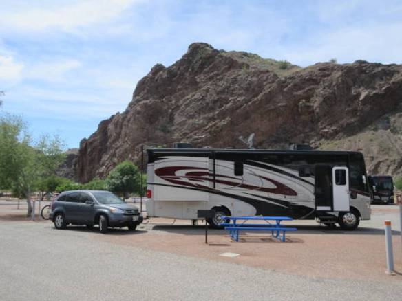
After getting another couple of hours sleep, I started packing for my 100 plus mile trip into Las Vegas. I didn’t rush since I needed to arrive after midday. Just before 11AM I got underway. The roads were good, but I did have a couple of climbs and descent. They weren’t any higher or steeper than I’ve encountered in the east. What was a complication was the wind. While it wasn’t particularly strong overall today, in the high open terrain a couple of good gusts really pushed me around.

vm1

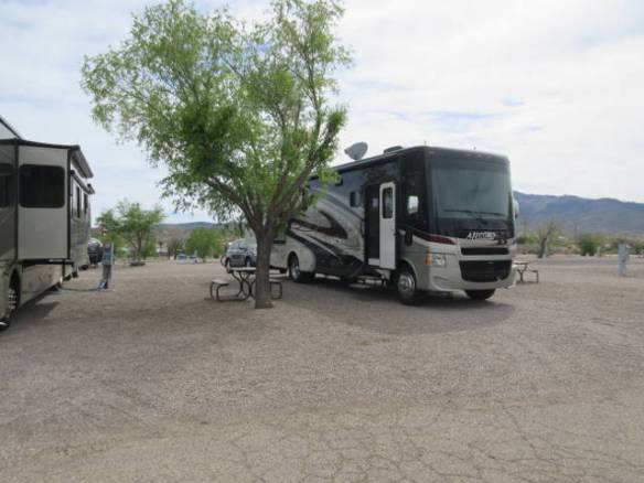
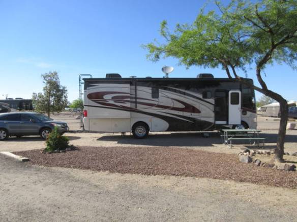
Site 152 at the Las Vegas RV Resort

I arrived at my home for the next two weeks shortly after 1PM. I’m staying at the Las Vegas RV Resort on Nellis Blvd. on the east side of the valley near the Boulder Strip. This is city camping. The sites are all located in a big flat paved lot. The boundary between sites is a painted line. For this type of facility it is one of the better I’ve encountered and the price isn’t too bad. My site is beside one of the restroom and laundry facilities so getting caught up on my laundry will be convenient.

The other good news is that whatever was keeping my TV reception from working has been fixed. Today’s bouncing around had a positive impact on what I assume was a loose connection. When I scanned for new channels on the TV I got 76 Over the Air channels. About a quarter of them are of no value to me. They are in Spanish.

vm2

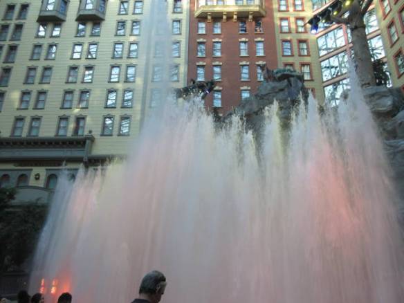
Sunset Stamped Laser and Water Show at Sams Town Casino

vm3

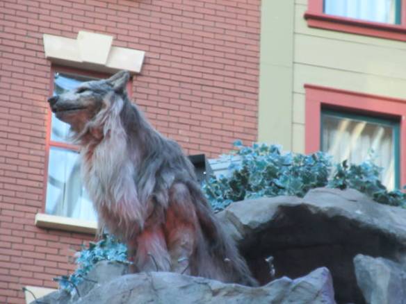
Animated Wolf holds court at the top of the waterfall.

This evening I got started on my site seeing. I went to the nearby Sams Town Casino to watch the Mystic Falls Indoor Park Sunset Stampede Laser Light and Water Show. I’ve seen this free attraction at Christmas time when it is appropriately themed. I don’t recall having watched the non Christmas version. I noticed on the web site that it will be closed for maintenance starting next week so I took the first opportunity to see the show. Some of the animated desert animals are showing signs of wear. I hope they will be fixed during the upcoming maintenance period. I would have enjoyed it more if the women beside me didn’t decide to hold a conversation with her companions over the volume of the music. It was as if she didn’t know there was a music component to the show. Sometime during the next week I may try to get back for one of the later shows when it will be darker.

vm4

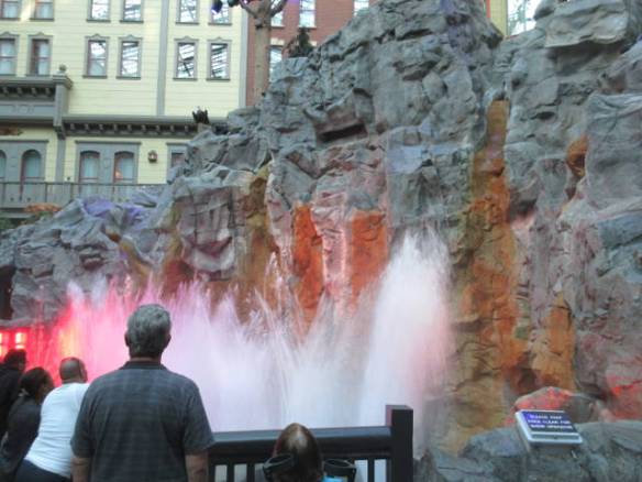
Dancing fountains in front of the waterfall.

Tomorrow I need to make some decisions on shows and turn some vague site seeing ideas into a plan.

Old, New, Big and Small Trains

Sunday April 9th 2017

Today’s theme was trains. I saw old trains, new trains, big trains and small trains. All on my exploration of this part of route 66.

I started the day at the Arizona Powerhouse Route 66 Museum in downtown Kingman. The building was the home of the first power generating plant in this part of the country. It served the greater Kingman area from 1907 until the Hoover dam power plant opened in 1938. The building also holds the destination of being the first reinforced concrete building in the state.

su1

Arizona Powerhouse Route 66 Museum

The Powerhouse building contains an information desk, gift shop, an overview of route 66 and the Arizona Route 66 Museum. I didn’t explore the museum. At the time, I thought it was an electric car museum. It was only when I was checking a couple of things on the internet for this blog entry that I learned the electric cars were only a small portion of the museum’s exhibits. I enjoyed the parts that weren’t behind the museum door. That’s where I saw my first train of the day. A very large old model train with route 66 era landscapes was routed around the 2nd floor area.

su2

Steam Locomotive retired from the Santa Fe line in 1953.

su3

Not a place I’d want to stand when this engine was operational.

Across the street from the museum is Locomotive park. It is the home of steam engine that made the run from Kansas City and Los Angles until 1953 on the Santa Fe line. Kingman was a water stop on the route. This is an impressive engine. The drive wheels are bigger in diameter than I am tall. They are 80 inches in diameter.

su4

Caboose attached to the engine and tender.

After the museum and Locomotive park, I drove out route 66 to the east. Unlike the road to the west of town, this portion of route 66 is a modern secondary road. I drove about 40 miles to the northeast before turning around. The road crosses the desert then climbs over and between ridge lines. There were interesting rock formations beside the road in the mountainous areas, but by far the most interesting thing was the train tracks that paralleled the road.

During my drive I saw six freight trains. Four were east bound and two were west bound. Each train was more than a mile long. They had three or four engines at the front and some had one or two engines at the rear. Most of the trains had a mixture of tank cars and modern box cars, but two of the biggest were packed 2 levels high with inter-modal containers. The containers could go from the train to truck transports or right onto a ship. I am not used to seeing so many trains this large. In the northeast they are traveling shorter distances carrying less.

Tomorrow I pack up and move one hundred plus miles up the road to Las Vegas. I’ll be there for two weeks.

Route 66 to Oatman AZ

Saturday April 8th 2017

Today I took a drive on old route 66. The iconic route connecting Chicago with Los Angles passes through this area. This is one of several areas across the country that celebrate the road and use its history as a tourist attraction.

st1

Desert in bloom at the base of the Black Mountains

The section of road I drove is now called the Historic Route 66 National Back Country Byway. It is a section of old route 66 that goes from Kingman AZ to Needles CA over the Black Mountains. It actually was replaced as route 66 in 1953 by a less mountainous route around most of the Black Mountain range through Yucca AZ following the path that is Interstate 40 today. I can understand why. This is a real mountain goat path up and over the mountains. The road is barely two lanes wide. It rarely has guard rails, tight turn and extreme drop offs are the norm. The west bound route, which I was on, had the drop off side all the way through the mountains. I seemed to always meet on coming traffic at the worst possible locations. The sign said no trucks over 40 feet long. I think it should have been no trucks period. Maybe that would have discouraged the one rental Class C motorhome I had to contend with.

st2

Historic Route 66 hugs the side of the mountains as it climbs to Sitgreaves pass.

I crossed over Sitgreaves Pass at 3556 feet and started down the west side. The scenery going up and the distant view coming down was very nice. Taking picture was out of the question. I had two hands on the wheel and there were no shoulders or pull offs. The trip down passes by an old gold mine that still has hopes of starting up again and the town of Oatman AZ.

Oatman was formed to support the gold mine. When the mine shutdown during World War II, the town still had the tourists traveling on route 66 to support it. The Oatman hotel is famous as the wedding night stop for Clark Gable and Carole Lombard in 1939. The town has been using that tidbit of trivia to support tourism ever since. When route 66 was redirected in 1953 the town suffered greatly. It’s resurgence as a pure tourist attraction is attributed to tours from the gambling centers of Laughlin and Las Vegas Nevada. My first exposure to the town was on a tour from Las Vegas.

st5

Shootout in front of the Oatman Hotel.

To enhance the tourist attraction of the town a couple of times a day a mock shoot out by bank robbers is held on old route 66. I watched one of the shows today. It is over the top campy, but fun to watch at least once. The other tourist attractions are “wild” burros. They are the decedents of burros that worked the mines in the area. They are wild in the sense that they are not bred by humans, and are not kept in fenced in areas. They are free to go where they want and they do. They are well feed by tourists using purchased cubes of grain and I think by the town.

st3

Burros stop traffic

st4

I hope this woman doesn’t have anything in her pockets.

st6

Time to try some other tourists.

st7

I’m less than 3 feet away.

Today there were three burros in the center of town and a group of ten or more blocking the road to the south of town. The three in town walked down the center of the street, on the board walks and tried to enter the tourist shops. They come right up to people looking for food and no problem sticking there heads into bags and pockets looking for food. They even posed for selfies with trusting tourists.

After Oatman, old route 66 proceeded across the desert toward Needles CA. I turned more directly west toward the Colorado river town of Bullhead City. This a large community across the river from Laughlin NV just down river from the Davis Dam. Bullhead City has the businesses that support the area. Laughlin has the hotels and casinos. I returned home on route 68 a nice divided highway across the Black mountains into the Golden Valley area near Kingman. It was a long steady climb up and down. I didn’t have to negotiate any hairpin turns or 10 mile per hour blind turns on this route. It was 55mph to 75mph all the way.

Travel to Kingman Az

Friday April 7th 2017

I got an early start this morning. My neighbors decided to pack and leave shortly after 5AM. I was sleeping with the windows open to take advantage of the nice temperature so I was wide awake far earlier than normal. At seven I gave up trying to get back to sleep. If I had a long travel day getting an early start wouldn’t have been bad, but I only had a little over a hundred miles to go today. Check in time was advertised as 2PM, but I checked in at 1PM. To arrive that late I dawdled on the way. A long gas stop, a pause at a rest area and an attempt to pause at a truck stop helped slow me down. The attempted truck stop pause was to close to the lunch hour. There was no room in the parking lot.

f1

One last picture of the sites and cliffs surrounding River Island SP.

f2

Visitor wishing me safe travels this morning.

The trip today was up and down over ridge lines followed by long stretches of desert. This is the Mohave desert that goes from here into California and Nevada. It has a different characteristic from the desert south and east of Phoenix. One thing is clear the plant life is different. Most of the plants in this part of the Mohave desert are close to the ground. There are no saguaro cactus, but there are some low to the ground varieties.

It was not a good travel day. It was cloudy and very windy. The wind in this territory is tricky. The desert doesn’t have good indicators of wind. Typically, I look for trees with blowing branches to warn me of the wind. Today I would realize that I have more steering wheel cut to go straight than normal or the transmission would downshift on level ground. The worst was a head wind while climbing a hill. I had a couple of slow climbs because I didn’t get into the gas quick enough.

For the next three nights I am staying in the Kingman Arizona area at Blake Ranch RV Park and Horse Motel. It is located on a hill side north of Interstate 40. I can look down on the highway from about a half a mile away. Historic route 66 goes through Kingman so I’ll be checking that out while I’m here.

f3

Site 22 at the Blake Ranch RV Park and Horse Motel

Cell service and internet access are better here. They still aren’t great but I should be able to maintain my daily blog posts. More importantly I can access the Internet when I want. I was starting to suffer from withdrawal not being able to look things up as soon as an idea passes through my brain. Now if I could just remember all the things I wanted to look up.

London Bridge in the Desert

Thursday April 6th 2017

I continue to have a weak cell and internet signal here at the River Island State Park. This blog updated will be posted on Friday the 7th after I get to my next location.

It was hot on the banks of the Colorado River today. The temperature topped out around 95 degrees with very little breeze.

r2

London Bridge over a channel in Lake Havasu viewed from the north

I drove about 25 miles north to visit the London Bridge and do some food shopping in Lake Havasu City. I’ve visited this area a couple of times before. The idea of moving an ordinary bridge with an iconic name from London England to the desert of Arizona continues to be a wild marketing idea. There is nothing special about the bridge other than the origin of the stone work. I drove across the bridge onto the island in the lake it connects to the mainland. Going across it you wouldn’t know it was anything special. Looking at it from the water side it is a stone arch bridge with a London England themed resort, tourist attraction and marina on the mainland side.

r3

London Bridge

It is a nice shop and recreation area. The town around the bridge has really grown over the years. The hills are packed with homes and there are new housing developments and shops under construction. I don’t recall the area being as developed the first time I visited the area about fifteen years ago. I guess bringing the bridge to the desert had the desired impact of selling property and developing a community. It is just many years later than the original developer intended.

r1

Desert tree in bloom

The grocery shopping I chose was at Walmart on the far north side of town. It was a fairly new and big store with the expected layout and products. There were other stores nearby including both types of home improvement stores and JC Penny. Closer to the center of town there were other food stores and discount stores. I’m taking the time to document these seemingly unimportant facts, because I am considering spending next December and January in this area.

There are several attractions in the area during December and January. The London Bridge area has a number of Christmas celebrations including a boat parade. In January a hot air balloon festival takes place. I think I’ve heard of other events, but without Internet I haven’t been able to do any research. The events are the upside. The downside is the temperature only averages in the fifties and sixties.

r4

A view of one of the rock cliffs surrounding the River Island State Park.

Back at the campsite this afternoon I retreated to the air conditioned comfort of the RV until around five when the sun slipped behind the nearby cliffs. I walked over to the river bank and watched the jet skis, speed boats and pontoon boats dodge the kayakers. It really looked to be dangerous in the small craft. There is a park ranger patrol boat parked in the parking lot of the State Park. I think they could do a lot of business trying to heard boaters.

Tomorrow I move one hundred miles and three thousand feet in elevation. It should be cooler and hopefully I’ll have cell service and internet.

Travel to River Island State Park

Wednesday April 5th 2017

My new location at the River Island State Park in Parker AZ is surrounded on three sides by rock cliffs and the fourth side has more cliffs in California on the other side of the Colorado River. I have very poor cell phone service. This post may not get online tonight. It may be delayed until I get to better service.

Today started very early on a sour note. I set the alarm and got up early at quarter to five. My goal was to score a reservation for next March at one of the Florida State Parks. The eleven month reservation window starts at eight eastern. Before I went to bed I identified four sites that would become available appropriate for my RV. I logged into the Reserve America web site just before the hour. All four sites were available. I clicked on my first choice to display the description. It was still available everything was looking good. I clicked the reserve button only to be told it was unavailable. This scenario repeated three more times. I was back in bed by 5:05 still without a reservation for next march.

w1

Site 14 at the River Island State Park

I was packed and on the road by ten. The wind was a little stronger than the forecast but it wasn’t a big problem. As I got further west the wind became much weaker. It was a lot of desert driving about half of it on the Interstate and half on state roads with on coming traffic to look out for. I arrived at the River Island State Park about one thirty and found my site. There was no park ranger on duty, but since I had a reservation the paper work and fee were already taken care of.

This is a nice campground with electric and water hookups. In addition to the campsites the park has a boat launch into the Colorado river. This portion of the river is just down stream, to the south, of the Parker Dam that creates Lake Havasu. It is very popular with boaters on the weekends. I have to leave on Friday to make room for them. Until then I’ll enjoy the area. It is forecast to be in the mid 90s tomorrow.

Travel to Gila Bend

Tuesday April 4th 2017

I moved to Gila Bend today. It is a little over 80 miles from my last stop. I chose the short travel day because I couldn’t get a reservation for tonight at the state park I’m staying at tomorrow and Thursday night. I’ll have between l75 and 200 miles to go tomorrow depending on the route I select.

tu1

Site 114 at the Gila Bend KOA.

Gila Bend is southwest of Phoenix. Interstate 8 brought me here from the southeast of Phoenix. The road is labeled as the Phoenix bypass. I’m all for it. The days I drove into the Phoenix suburbs for the Spring Training Games were not fun driving. There was no traffic at all on I-8, but there was a steady head wind. That may have been why I felt like I was climbing in altitude the whole way. I wasn’t gaining altitude, I lost 1000 feet.

Probably because of the change in altitude, the desert in this area is different. There are very few saguaro cactus. The plants seem to be much lower to the ground and there are more desert plants in bloom. I passed through areas of bright yellow on both sides of the road. It was a very pretty drive. I imagine it would be pretty bleak at other times of the year.

The trip was not particularly bumpy, but it took its toll on the motorhome. I currently can’t receive any Over the Air or Cable TV on any of my three TVs. I can still watch Directv satellite so I’m not desperate. My guess is that a cable has vibrated loose. The first access panel I checked behind was a mass of cables, but they all seemed to be OK. I don’t have a wiring diagram for the TV cables, but I think the OTA and Cable lines come together into a single line in a device that also provides power to the antenna. Then the single line is split into a line for each TV. I’ve found the splitter, just not the combiner. I’ll dig into the problem some more in the next few days. It is always something.

Wind and Planning

Monday April 3rd 2017

Temperature and sunshine wise, today was a lot like yesterday. The difference was the wind. At times today the wind was so strong you couldn’t comfortably be outside. On one attempt at a walk around the campground, I was holding my hat with one hand, leaning into the wind and trying to walk in a straight line. I spent most of the day inside.

m1

Cactus in a line

I spent the day on the computer and phone working on travel and sightseeing plans. I have all of my campground reservations through the 24th of the month when I leave Las Vegas. To a certain extent, I have to make commitments sequentially. I’m now working on the Reno, Lake Tahoe area after Las Vegas. I’m going to take a chance on the stops between the two locations. If I don’t find suitable campgrounds, there is always a parking lot for the night. In the Reno NV area I have narrowed the search to two campgrounds, but they are expensive. I need to be sure before I lock in the location.

After the Reno area I will move on to Twin Falls Idaho for a week or so that will include the Memorial Day weekend. Right now places that allow you to look at their booking online have plenty of room over the holiday. These may be famous last words, but I think I still have time to commit to a location for the holiday. At the beginning of June, I will make my way to the Missoula Montana area for a few days, then up to the West Glacier National Park area. How long I spend in the southern Montana area depends on where and when I book my Glacier National Park stay. I started making lists of things to do in each area to figure out how long I can stay before I run out of interesting things. The campgrounds in this area are expensive and well booked already. Ninety dollars a night is more than I want to pay. I’ll trade distance from the park for cost to mitigate the expense.

From Glacier NP I’ll have a little over 3 weeks to get to the Salt Lake City area. I spent time researching that route and possible stops as well. After my stay in the Salt Lake City area I’ll move up into the Park City area for the first half of August. The second half of August I’ll work my way south toward the lower part of Utah. September will be the National parks of Utah. October will probably be the Grand Canyon area of Arizona and possibly the Monument Valley area of southeastern Utah. All of the options keep me from committing. I also believe that what I miss this time around I’ll catch next time.

In addition to all of these planning activities I’ve been working on a couple of other planning items. I’m trying to identify the shows I want to see in Vegas and the best way to buy the tickets. The cheapest way is the same day ticket sales on the strip, but that is not always the best way. The seats you get aren’t always optimal.

The other planning activity is for next March. The booking window for the Florida State Parks is 11 months. The campsites in some of the parks get book very quickly. I’ve already missed the two weeks starting on March 1st, 2nd and 3rd. I’m trying to figure out when the daily booking window opens. It isn’t midnight eastern and it is before 10am eastern. Hopefully, I’ll figure it out before the month is gone.

m2

One last cactus picture. I’m moving out of the area they are predominate. There is a bird on the left arm.

Tomorrow I resume my march across the state of Arizona. I’m going about 80 miles to Gila Bend so I can reach the River Island State Park on the Colorado River Wednesday. I could only get two nights there so I’ll move up to the Kingman AZ area for the weekend.

Walking in the Desert at Picacho Peak

Sunday April 2nd 2017

Today was a perfect day. The temperature topped out in the mid 70s will bright sunshine and a light breeze. I hung around camp and enjoyed the Picacho Peak State Park.

sn1

Patio area at my campsite.

sn2

Picacho Peak behind a campsite.

sn3

A young and old saguaro cactus

This area fits my stereotype of the desert southwest. I’m really enjoying walking the roads and paths of the park and soaking in my surroundings. I’ve been taking lots of pictures. Some of them are starting to get repetitive, but I don’t care. Tonight’s blog contains many of those pictures.

sn4

Wildflower in bloom

sn6

Desert in evening light

sn8

My RV home is hiding behind the cactus in the tree.

sn9

Sunset in the desert

Picacho Peak

Saturday April 1st 2017

Today was moving day. I completed packing away the month’s worth of clutter around ten thirty this morning. I hooked up the car and was on my way. As anticipated I wasn’t the only one leaving. One of my neighbors was gone before I got up and several more departed while I was getting everything ready for the road. While saying goodbye to my neighbors from Canada, I learned they were leaving by Thursday, so the area will be pretty empty before too long.

sa1

Site A3 at Picacho Peak State Park. This picture was taken during the part of the afternoon that threatened rain.

I had a very short travel day. My stop for the next three nights is the Picacho Peak State Park about 20 miles east on Interstate 10 from my home for the last month. Picacho Peak is a prominent hunk of rock that towers 1,500 feet above the desert floor. It can be seen from many miles around. The campground is located on the high ground on the north side of the Peak.

sa2

Looking at the Peak from behind my RV.

My campsite is located in one of three loops in an area with many saguaro cacti. This is a back to nature stay. After the month in the regular rows of a trailer park like setting, this is a welcome change. The sites have electric hookups but no water or sewer. I came prepared with a full water tank and empty waste tanks. I plan to hike a couple of the trails while I’m here.

sa3

Smaller Peak between Picacho and the Interstate highway.

On the planning front, I managed to secure a campsite in Las Vegas for two weeks. My fear that I would have difficulty proved unfounded. The first place I called had an available site at a reasonable price. Now I need to look at the show schedule while I’m there. I want to see a few shows while I’m in town.

sa4

Looking at Picacho Peak from across the campground.

My next two stops before I get to Vegas are reserved. I still need to research and book a campground in the Kingman AZ area for next weekend. There are several campgrounds listed in the directories, but I need to check the online review sites for the prevailing opinions.